Ar Raqqah elevation
Ar Raqqah (Ar-Raqqah), Syria elevation is 259 meters and Ar Raqqah elevation in feet is 850 ft above sea level [src 1]. Ar Raqqah is a seat of a first-order administrative division (feature code) with elevation that is 270 meters (886 ft) smaller than average city elevation in Syria.
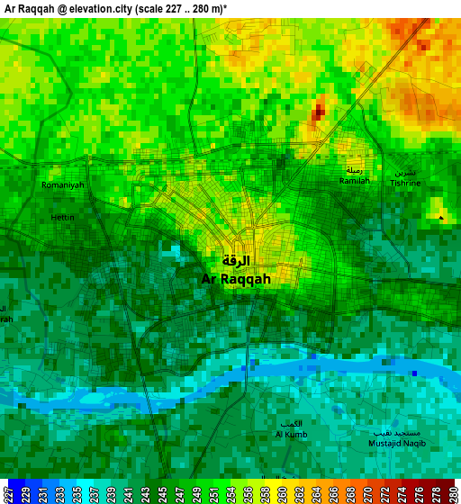
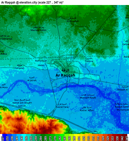
Below is the Elevation map of Ar Raqqah, which displays elevation range with different colors. Scale of the first map is from 227 to 280 m (745 to 919 ft) with average elevation of 247.7 meters (=813 ft) [note 1]
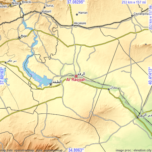
These maps also provides idea of topography and contour of this city, they are displayed at different zoom levels. More info about maps, scale and edge coordinates you can find below images.
| \ | Map #1 | Map #2 | Topo.Map |
| Scale [m] | 227..280 m | 227..347 m | × |
| Scale [ft] | 745..919 ft | 745..1138 ft | × |
| Average | 247.7 m = 813 ft | 256.1 m = 840 ft | × |
| Width | 7.91 km = 4.9 mi | 15.82 km = 9.8 mi | 253.1 km = 157.3 mi |
| Height | 7.91 km = 4.9 mi | 15.82 km = 9.8 mi | 253.1 km = 157.3 mi |
| ↑Max Latitude | 35.988396° | 36.023945° | 37.08295° |
| Latitude at center | 35.95283° | 35.95283° | 35.95283° |
| ↓Min Latitude | 35.917248° | 35.88165° | 34.8063° |
| ← Min Longitude | 38.963935° | 38.919989° | 37.60163° |
| Longitude center | 39.00788° | 39.00788° | 39.00788° |
| →Max Longitude | 39.051825° | 39.095771° | 40.41413° |
Nearby cities:
Cities around Ar Raqqah sort by population:
• Ath Thawrah elevation 342 m
43.3 km,  252°
252°
• Al Kasrah 246 m
92.8 km,  117°
117°
• Maskanah 376 m
87 km,  270°
270°
• Tall Abyaḑ 351 m
82.8 km,  356°
356°
• At Tibnī 227 m
82.3 km, 117°
• Al Jarnīyah 376 m
73.4 km,  288°
288°
• Sulūk 343 m
72.3 km,  8°
8°
• Ma‘dān 226 m
57.6 km,  112°
112°
• ‘Ayn ‘Īsá 340 m
49.9 km,  344°
344°
• As Sabkhah 251 m
27.8 km, 124°
• Al Manşūrah 269 m
27 km,  242°
242°
• Al Karāmah 244 m
26.1 km, 111°
Multilingual:
 En español:
Raqqa elevación 259 m.
 En France:
Ar Raqqah élévation 259 m.
 Auf Deutsch:
Ar-Raqqah höhe über dem Meeresspiegel ist 259 m.

Sources and notes:
- [note 1] Map square and city borders are not equal. Map elevation data is calculated only from area inside that square.
- [src 1] Elevation data from geonames database provided with same terms of usage.
- [src 2] The elevation map of Ar Raqqah is generated using elevation data from NASA's 3 arcsec (90m) resolution SRTM data.
- [src 3] Base (background) map © OpenStreetMap contributors tiles are generated by Geofabrik and OpenTopoMap.
Copyright & License:
This Ar Raqqah Elevation Map is licensed under CC BY-SA. You may reuse any part from this page, if you give a proper credit by linking to this URL:
 More info on terms of use page.