Majšperk elevation
Majšperk, Slovenia elevation is 283 meters and Majšperk elevation in feet is 928 ft above sea level [src 1]. Majšperk is a seat of a first-order administrative division (feature code) with elevation that is 31 meters (102 ft) smaller than average city elevation in Slovenia.
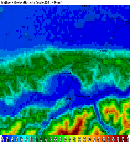
Below is the Elevation map of Majšperk, which displays elevation range with different colors. Scale of the first map is from 226 to 490 m (741 to 1608 ft) with average elevation of 275.4 meters (=904 ft) [note 1]
These maps also provides idea of topography and contour of this city, they are displayed at different zoom levels. More info about maps, scale and edge coordinates you can find below images.
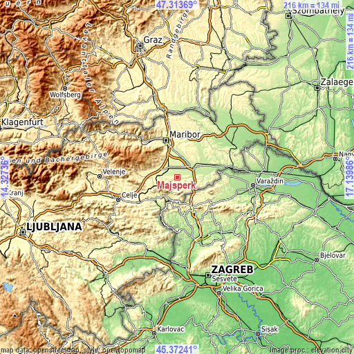
| \ | Map #1 | Topo.Map |
| Scale [m] | 226..490 m | × |
| Scale [ft] | 741..1608 ft | × |
| Average | 275.4 m = 904 ft | × |
| Width | 6.75 km = 4.2 mi | 215.9 km = 134.2 mi |
| Height | 6.75 km = 4.2 mi | 215.8 km = 134.1 mi |
| ↑Max Latitude | 46.381994° | 47.31369° |
| Latitude at center | 46.35167° | 46.35167° |
| ↓Min Latitude | 46.321329° | 45.37241° |
| ← Min Longitude | 15.689665° | 14.32736° |
| Longitude center | 15.73361° | 15.73361° |
| →Max Longitude | 15.777555° | 17.13986° |
Nearby cities:
Cities around Majšperk sort by population:
• Ptuj elevation 237 m
12.9 km,  54°
54°
• Slovenska Bistrica 274 m
13 km,  290°
290°
• Rače 262 m
11.8 km,  340°
340°
• Kidričevo 239 m
7.3 km,  37°
37°
• Zgornja Polskava 294 m
12.4 km,  311°
311°
• Poljčane 260 m
12.7 km,  249°
249°
• Pragersko 250 m
7.5 km, 311°
• Starše 240 m
13 km,  11°
11°
• Žetale 312 m
11.2 km,  140°
140°
• Podlehnik 231 m
11.4 km,  99°
99°
• Spodnja Hajdina 223 m
10.8 km, 53°
• Makole 260 m
6.4 km,  233°
233°
Multilingual:
 En español:
Majšperk elevación 283 m.
 En France:
Majšperk élévation 283 m.
 Auf Deutsch:
Majšperk höhe über dem Meeresspiegel ist 283 m.

Sources and notes:
- [note 1] Map square and city borders are not equal. Map elevation data is calculated only from area inside that square.
- [src 1] Elevation data from geonames database provided with same terms of usage.
- [src 2] The elevation map of Majšperk is generated using elevation data from NASA's 3 arcsec (90m) resolution SRTM data.
- [src 3] Base (background) map © OpenStreetMap contributors tiles are generated by Geofabrik and OpenTopoMap.
Copyright & License:
This Majšperk Elevation Map is licensed under CC BY-SA. You may reuse any part from this page, if you give a proper credit by linking to this URL:
 More info on terms of use page.