Žetale elevation
Žetale, Slovenia elevation is 312 meters and Žetale elevation in feet is 1024 ft above sea level [src 1]. Žetale is a seat of a first-order administrative division (feature code) with elevation that is 2 meters (7 ft) smaller than average city elevation in Slovenia.
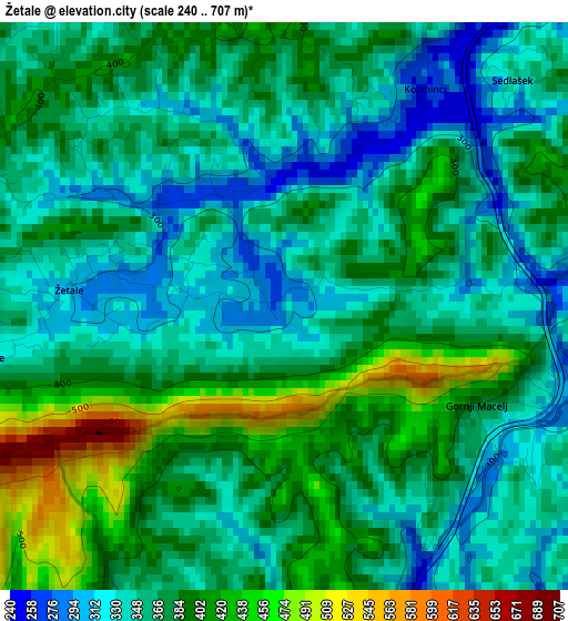
Below is the Elevation map of Žetale, which displays elevation range with different colors. Scale of the first map is from 240 to 707 m (787 to 2320 ft) with average elevation of 367.9 meters (=1207 ft) [note 1]
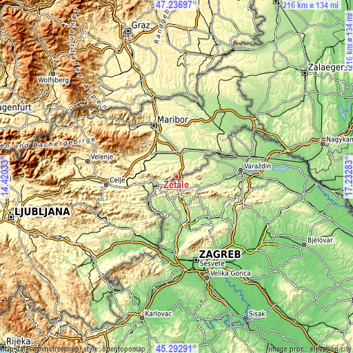
These maps also provides idea of topography and contour of this city, they are displayed at different zoom levels. More info about maps, scale and edge coordinates you can find below images.
| \ | Map #1 | Topo.Map |
| Scale [m] | 240..707 m | × |
| Scale [ft] | 787..2320 ft | × |
| Average | 367.9 m = 1207 ft | × |
| Width | 6.75 km = 4.2 mi | 216.2 km = 134.3 mi |
| Height | 6.75 km = 4.2 mi | 216.1 km = 134.3 mi |
| ↑Max Latitude | 46.303927° | 47.23697° |
| Latitude at center | 46.27356° | 46.27356° |
| ↓Min Latitude | 46.243176° | 45.29291° |
| ← Min Longitude | 15.782635° | 14.42033° |
| Longitude center | 15.82658° | 15.82658° |
| →Max Longitude | 15.870525° | 17.23283° |
Nearby cities:
Cities around Žetale sort by population:
• Ptuj elevation 237 m
16.6 km,  11°
11°
• Rogaška Slatina 237 m
14.9 km,  254°
254°
• Rogatec 241 m
10.9 km,  243°
243°
• Kidričevo 239 m
14.7 km,  349°
349°
• Pragersko 250 m
18.7 km,  316°
316°
• Majšperk 283 m
11.2 km, 320°
• Videm pri Ptuju 219 m
12.2 km,  30°
30°
• Markovci 222 m
15.7 km, 29°
• Cirkulane 240 m
15.1 km,  58°
58°
• Podlehnik 231 m
8 km, 30°
• Spodnja Hajdina 223 m
15.1 km, 5°
• Makole 260 m
13.2 km,  291°
291°
Multilingual:
 En español:
Žetale elevación 312 m.
 En France:
Žetale élévation 312 m.


Sources and notes:
- [note 1] Map square and city borders are not equal. Map elevation data is calculated only from area inside that square.
- [src 1] Elevation data from geonames database provided with same terms of usage.
- [src 2] The elevation map of Žetale is generated using elevation data from NASA's 3 arcsec (90m) resolution SRTM data.
- [src 3] Base (background) map © OpenStreetMap contributors tiles are generated by Geofabrik and OpenTopoMap.
Copyright & License:
This Žetale Elevation Map is licensed under CC BY-SA. You may reuse any part from this page, if you give a proper credit by linking to this URL:
 More info on terms of use page.