Rogaška Slatina elevation
Rogaška Slatina, Slovenia elevation is 237 meters and Rogaška Slatina elevation in feet is 778 ft above sea level [src 1]. Rogaška Slatina is a seat of a first-order administrative division (feature code) with elevation that is 77 meters (253 ft) smaller than average city elevation in Slovenia.
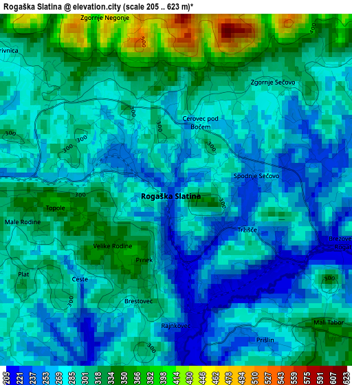
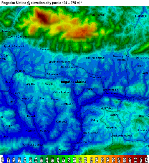
Below is the Elevation map of Rogaška Slatina, which displays elevation range with different colors. Scale of the first map is from 205 to 623 m (673 to 2044 ft) with average elevation of 295.2 meters (=969 ft) [note 1]
These maps also provides idea of topography and contour of this city, they are displayed at different zoom levels. More info about maps, scale and edge coordinates you can find below images.
| \ | Map #1 | Map #2 | Topo.Map |
| Scale [m] | 205..623 m | 194..975 m | × |
| Scale [ft] | 673..2044 ft | 636..3199 ft | × |
| Average | 295.2 m = 969 ft | 340.6 m = 1117 ft | × |
| Width | 6.76 km = 4.2 mi | 13.52 km = 8.4 mi | 216.3 km = 134.4 mi |
| Height | 6.76 km = 4.2 mi | 13.52 km = 8.4 mi | 216.3 km = 134.4 mi |
| ↑Max Latitude | 46.267887° | 46.298258° | 47.20155° |
| Latitude at center | 46.2375° | 46.2375° | 46.2375° |
| ↓Min Latitude | 46.207096° | 46.176675° | 45.25621° |
| ← Min Longitude | 15.595775° | 15.551829° | 14.23347° |
| Longitude center | 15.63972° | 15.63972° | 15.63972° |
| →Max Longitude | 15.683665° | 15.727611° | 17.04597° |
Nearby cities:
Cities around Rogaška Slatina sort by population:
• Slovenska Bistrica elevation 274 m
18 km,  343°
343°
• Slovenske Konjice 320 m
19.8 km,  303°
303°
• Šentjur 301 m
18.8 km,  263°
263°
• Šmarje pri Jelšah 239 m
9.3 km, 262°
• Rogatec 241 m
4.7 km,  100°
100°
• Poljčane 260 m
9.5 km,  330°
330°
• Pragersko 250 m
17.8 km,  5°
5°
• Kozje 285 m
19.1 km,  198°
198°
• Majšperk 283 m
14.6 km,  29°
29°
• Podčetrtek 220 m
9.5 km, 199°
• Žetale 312 m
14.9 km,  74°
74°
• Makole 260 m
9.1 km, 13°
Multilingual:
 En español:
Rogaška Slatina elevación 237 m.
 En France:
Rogaška Slatina élévation 237 m.
 Auf Deutsch:
Rogaška Slatina höhe über dem Meeresspiegel ist 237 m.

Sources and notes:
- [note 1] Map square and city borders are not equal. Map elevation data is calculated only from area inside that square.
- [src 1] Elevation data from geonames database provided with same terms of usage.
- [src 2] The elevation map of Rogaška Slatina is generated using elevation data from NASA's 3 arcsec (90m) resolution SRTM data.
- [src 3] Base (background) map © OpenStreetMap contributors tiles are generated by Geofabrik and OpenTopoMap.
Copyright & License:
This Rogaška Slatina Elevation Map is licensed under CC BY-SA. You may reuse any part from this page, if you give a proper credit by linking to this URL:
 More info on terms of use page.