Makole elevation
Makole, Slovenia elevation is 260 meters and Makole elevation in feet is 853 ft above sea level [src 1]. Makole is a seat of a first-order administrative division (feature code) with elevation that is 54 meters (177 ft) smaller than average city elevation in Slovenia.
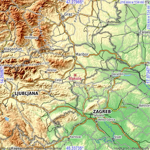
Below is the Elevation map of Makole, which displays elevation range with different colors. Scale of the first map is from 234 to 735 m (768 to 2411 ft) with average elevation of 333.2 meters (=1093 ft) [note 1]
These maps also provides idea of topography and contour of this city, they are displayed at different zoom levels. More info about maps, scale and edge coordinates you can find below images.

| \ | Map #1 | Topo.Map |
| Scale [m] | 234..735 m | × |
| Scale [ft] | 768..2411 ft | × |
| Average | 333.2 m = 1093 ft | × |
| Width | 6.75 km = 4.2 mi | 216 km = 134.2 mi |
| Height | 6.75 km = 4.2 mi | 216 km = 134.2 mi |
| ↑Max Latitude | 46.347563° | 47.27985° |
| Latitude at center | 46.31722° | 46.31722° |
| ↓Min Latitude | 46.28686° | 45.33735° |
| ← Min Longitude | 15.623275° | 14.26097° |
| Longitude center | 15.66722° | 15.66722° |
| →Max Longitude | 15.711165° | 17.07347° |
Nearby cities:
Cities around Makole sort by population:
• Slovenska Bistrica elevation 274 m
11 km,  319°
319°
• Rogaška Slatina 237 m
9.1 km,  193°
193°
• Rače 262 m
15 km,  4°
4°
• Šmarje pri Jelšah 239 m
15.2 km,  228°
228°
• Rogatec 241 m
10.1 km,  165°
165°
• Kidričevo 239 m
13.5 km,  44°
44°
• Zgornja Polskava 294 m
12.8 km,  340°
340°
• Poljčane 260 m
6.8 km,  265°
265°
• Pragersko 250 m
8.9 km,  356°
356°
• Morje 310 m
14.6 km,  346°
346°
• Majšperk 283 m
6.4 km,  53°
53°
• Žetale 312 m
13.2 km,  111°
111°
Multilingual:
 En español:
Makole elevación 260 m.
 En France:
Makole élévation 260 m.


Sources and notes:
- [note 1] Map square and city borders are not equal. Map elevation data is calculated only from area inside that square.
- [src 1] Elevation data from geonames database provided with same terms of usage.
- [src 2] The elevation map of Makole is generated using elevation data from NASA's 3 arcsec (90m) resolution SRTM data.
- [src 3] Base (background) map © OpenStreetMap contributors tiles are generated by Geofabrik and OpenTopoMap.
Copyright & License:
This Makole Elevation Map is licensed under CC BY-SA. You may reuse any part from this page, if you give a proper credit by linking to this URL:
 More info on terms of use page.