Rače elevation
Rače (Rače-Fram), Slovenia elevation is 262 meters and Rače elevation in feet is 860 ft above sea level [src 1]. Rače is a seat of a first-order administrative division (feature code) with elevation that is 52 meters (171 ft) smaller than average city elevation in Slovenia.
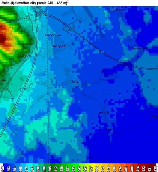
Below is the Elevation map of Rače, which displays elevation range with different colors. Scale of the first map is from 246 to 438 m (807 to 1437 ft) with average elevation of 267.5 meters (=878 ft) [note 1]
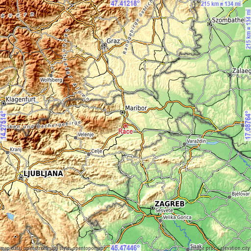
These maps also provides idea of topography and contour of this city, they are displayed at different zoom levels. More info about maps, scale and edge coordinates you can find below images.
| \ | Map #1 | Topo.Map |
| Scale [m] | 246..438 m | × |
| Scale [ft] | 807..1437 ft | × |
| Average | 267.5 m = 878 ft | × |
| Width | 6.73 km = 4.2 mi | 215.5 km = 133.9 mi |
| Height | 6.73 km = 4.2 mi | 215.4 km = 133.8 mi |
| ↑Max Latitude | 46.482208° | 47.41218° |
| Latitude at center | 46.45194° | 46.45194° |
| ↓Min Latitude | 46.421655° | 45.47446° |
| ← Min Longitude | 15.637445° | 14.27514° |
| Longitude center | 15.68139° | 15.68139° |
| →Max Longitude | 15.725335° | 17.08764° |
Nearby cities:
Cities around Rače sort by population:
• Miklavž na Dravskem Polju elevation 259 m
6.1 km,  11°
11°
• Spodnje Hoče 276 m
5.9 km,  335°
335°
• Zgornji Duplek 264 m
7.5 km,  23°
23°
• Radizel 281 m
3.2 km,  321°
321°
• Spodnji Duplek 236 m
7.5 km,  40°
40°
• Rogoza 268 m
5.3 km,  1°
1°
• Hotinja Vas 268 m
2 km,  325°
325°
• Zgornja Polskava 294 m
6.1 km,  241°
241°
• Pragersko 250 m
6.4 km,  194°
194°
• Morje 310 m
4.7 km,  259°
259°
• Fram 322 m
4 km,  276°
276°
• Starše 240 m
6.8 km,  76°
76°
Multilingual:
 En español:
Rače elevación 262 m.
 En France:
Rače élévation 262 m.


Sources and notes:
- [note 1] Map square and city borders are not equal. Map elevation data is calculated only from area inside that square.
- [src 1] Elevation data from geonames database provided with same terms of usage.
- [src 2] The elevation map of Rače is generated using elevation data from NASA's 3 arcsec (90m) resolution SRTM data.
- [src 3] Base (background) map © OpenStreetMap contributors tiles are generated by Geofabrik and OpenTopoMap.
Copyright & License:
This Rače Elevation Map is licensed under CC BY-SA. You may reuse any part from this page, if you give a proper credit by linking to this URL:
 More info on terms of use page.