Miklavž na Dravskem Polju elevation
Miklavž na Dravskem Polju, Slovenia elevation is 259 meters and Miklavž na Dravskem Polju elevation in feet is 850 ft above sea level [src 1]. Miklavž na Dravskem Polju is a seat of a first-order administrative division (feature code) with elevation that is 55 meters (180 ft) smaller than average city elevation in Slovenia.
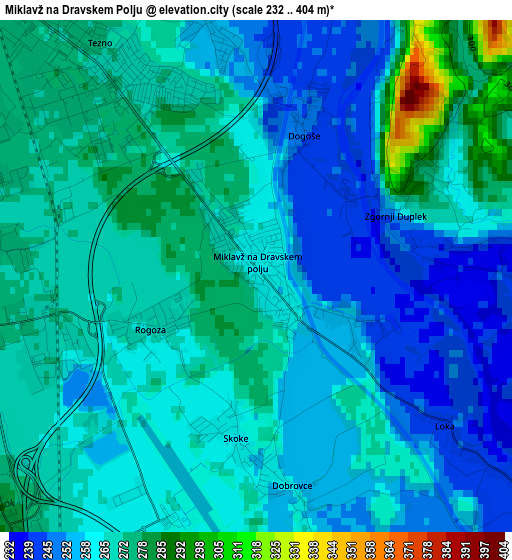
Below is the Elevation map of Miklavž na Dravskem Polju, which displays elevation range with different colors. Scale of the first map is from 232 to 404 m (761 to 1325 ft) with average elevation of 263.8 meters (=865 ft) [note 1]
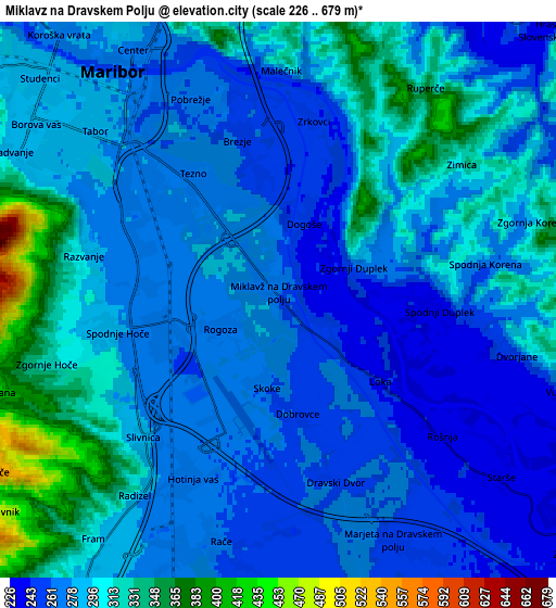
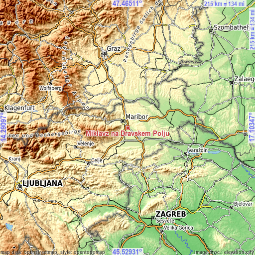
These maps also provides idea of topography and contour of this city, they are displayed at different zoom levels. More info about maps, scale and edge coordinates you can find below images.
| \ | Map #1 | Map #2 | Topo.Map |
| Scale [m] | 232..404 m | 226..679 m | × |
| Scale [ft] | 761..1325 ft | 741..2228 ft | × |
| Average | 263.8 m = 865 ft | 286.8 m = 941 ft | × |
| Width | 6.73 km = 4.2 mi | 13.45 km = 8.4 mi | 215.2 km = 133.7 mi |
| Height | 6.73 km = 4.2 mi | 13.45 km = 8.4 mi | 215.2 km = 133.7 mi |
| ↑Max Latitude | 46.536068° | 46.56629° | 47.46511° |
| Latitude at center | 46.50583° | 46.50583° | 46.50583° |
| ↓Min Latitude | 46.475575° | 46.445303° | 45.52931° |
| ← Min Longitude | 15.653275° | 15.609329° | 14.29097° |
| Longitude center | 15.69722° | 15.69722° | 15.69722° |
| →Max Longitude | 15.741165° | 15.785111° | 17.10347° |
Nearby cities:
Cities around Miklavž na Dravskem Polju sort by population:
• Maribor elevation 266 m
6.7 km,  324°
324°
• Spodnje Hoče 276 m
3.7 km,  259°
259°
• Rače 262 m
6.1 km,  191°
191°
• Zgornji Duplek 264 m
2 km,  64°
64°
• Radizel 281 m
4.7 km,  222°
222°
• Spodnji Duplek 236 m
3.7 km,  94°
94°
• Rogoza 268 m
1.2 km,  238°
238°
• Razvanje 297 m
4.8 km,  281°
281°
• Hotinja Vas 268 m
4.9 km,  208°
208°
• Morje 310 m
9 km, 220°
• Fram 322 m
7.6 km, 222°
• Starše 240 m
7 km,  129°
129°
Multilingual:
 En español:
Miklavž na Dravskem Polju elevación 259 m.
 En France:
Miklavž na Dravskem Polju élévation 259 m.
 Auf Deutsch:
Miklavž na Dravskem Polju höhe über dem Meeresspiegel ist 259 m.
 На русском:
Miklavž na Dravskem Polju высота над уровнем моря 259 м
Sources and notes:
- [note 1] Map square and city borders are not equal. Map elevation data is calculated only from area inside that square.
- [src 1] Elevation data from geonames database provided with same terms of usage.
- [src 2] The elevation map of Miklavž na Dravskem Polju is generated using elevation data from NASA's 3 arcsec (90m) resolution SRTM data.
- [src 3] Base (background) map © OpenStreetMap contributors tiles are generated by Geofabrik and OpenTopoMap.
Copyright & License:
This Miklavž na Dravskem Polju Elevation Map is licensed under CC BY-SA. You may reuse any part from this page, if you give a proper credit by linking to this URL:
 More info on terms of use page.