Ptuj elevation
Ptuj, Slovenia elevation is 237 meters and Ptuj elevation in feet is 778 ft above sea level [src 1]. Ptuj is a seat of a first-order administrative division (feature code) with elevation that is 77 meters (253 ft) smaller than average city elevation in Slovenia.
Below is the Elevation map of Ptuj, which displays elevation range with different colors. Scale of the first map is from 212 to 326 m (696 to 1070 ft) with average elevation of 234 meters (=768 ft) [note 1]
These maps also provides idea of topography and contour of this city, they are displayed at different zoom levels. More info about maps, scale and edge coordinates you can find below images.
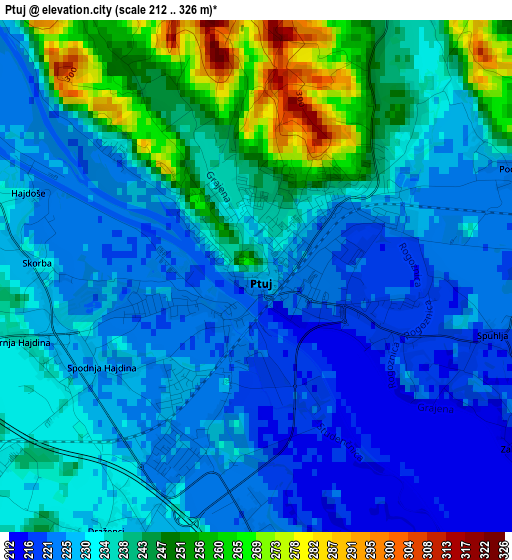
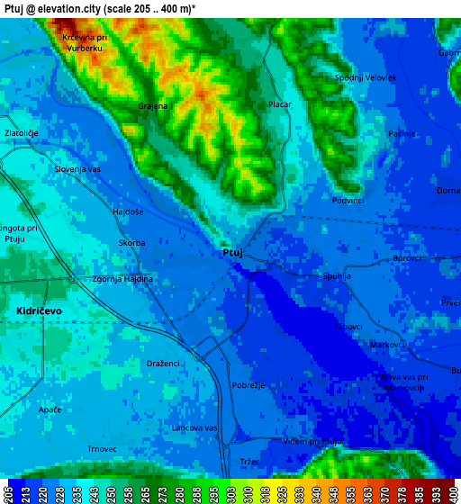
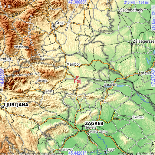
| \ | Map #1 | Map #2 | Topo.Map |
| Scale [m] | 212..326 m | 205..400 m | × |
| Scale [ft] | 696..1070 ft | 673..1312 ft | × |
| Average | 234 m = 768 ft | 239.2 m = 785 ft | × |
| Width | 6.74 km = 4.2 mi | 13.47 km = 8.4 mi | 215.6 km = 134 mi |
| Height | 6.74 km = 4.2 mi | 13.47 km = 8.4 mi | 215.6 km = 134 mi |
| ↑Max Latitude | 46.450336° | 46.480605° | 47.38086° |
| Latitude at center | 46.42005° | 46.42005° | 46.42005° |
| ↓Min Latitude | 46.389747° | 46.359428° | 45.44201° |
| ← Min Longitude | 15.826235° | 15.782289° | 14.46393° |
| Longitude center | 15.87018° | 15.87018° | 15.87018° |
| →Max Longitude | 15.914125° | 15.958071° | 17.27643° |
Nearby cities:
Cities around Ptuj sort by population:
• Dornava elevation 217 m
6.7 km,  73°
73°
• Kidričevo 239 m
6.3 km,  253°
253°
• Starše 240 m
9.4 km,  302°
302°
• Gorišnica 210 m
11 km,  93°
93°
• Videm pri Ptuju 219 m
6.4 km,  154°
154°
• Markovci 222 m
5.2 km,  121°
121°
• Cirkulane 240 m
12.8 km,  131°
131°
• Podlehnik 231 m
9.5 km,  175°
175°
• Trnovska Vas 247 m
11.2 km,  6°
6°
• Juršinci 235 m
10.6 km,  47°
47°
• Spodnja Hajdina 223 m
2.2 km,  235°
235°
• Destrnik 348 m
8.1 km,  4°
4°
Multilingual:
 En español:
Ptuj elevación 237 m.
 En France:
Ptuj élévation 237 m.
 Auf Deutsch:
Pettau, Ptuj höhe über dem Meeresspiegel ist 237 m.

Sources and notes:
- [note 1] Map square and city borders are not equal. Map elevation data is calculated only from area inside that square.
- [src 1] Elevation data from geonames database provided with same terms of usage.
- [src 2] The elevation map of Ptuj is generated using elevation data from NASA's 3 arcsec (90m) resolution SRTM data.
- [src 3] Base (background) map © OpenStreetMap contributors tiles are generated by Geofabrik and OpenTopoMap.
Copyright & License:
This Ptuj Elevation Map is licensed under CC BY-SA. You may reuse any part from this page, if you give a proper credit by linking to this URL:
 More info on terms of use page.