Baymak elevation
Baymak (Bashkortostan Republic), Russia elevation is 502 meters and Baymak elevation in feet is 1647 ft above sea level [src 1]. Baymak is a populated place (feature code) with elevation that is 303 meters (994 ft) bigger than average city elevation in Russia.
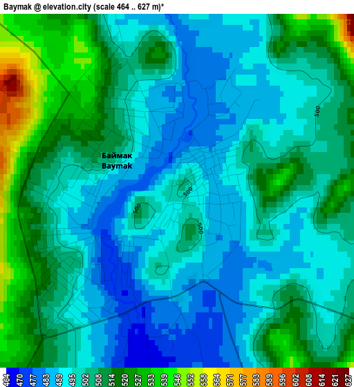
Below is the Elevation map of Baymak, which displays elevation range with different colors. Scale of the first map is from 464 to 627 m (1522 to 2057 ft) with average elevation of 503.1 meters (=1651 ft) [note 1]
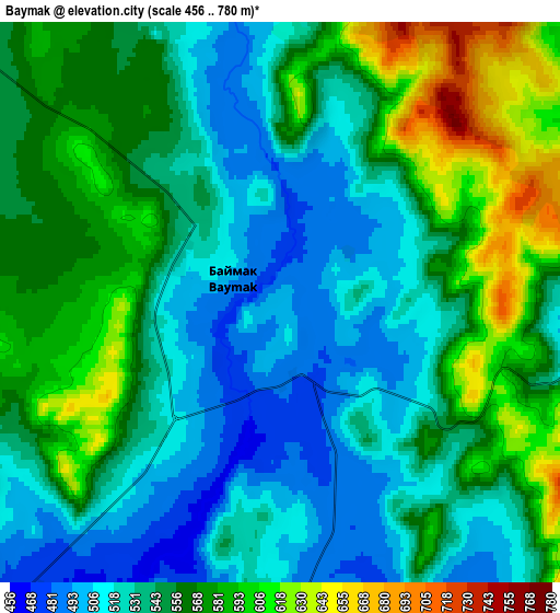
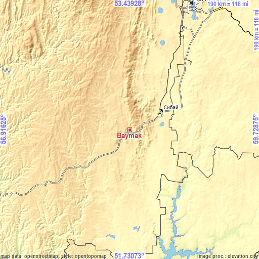
These maps also provides idea of topography and contour of this city, they are displayed at different zoom levels. More info about maps, scale and edge coordinates you can find below images.
| \ | Map #1 | Map #2 | Topo.Map |
| Scale [m] | 464..627 m | 456..780 m | × |
| Scale [ft] | 1522..2057 ft | 1496..2559 ft | × |
| Average | 503.1 m = 1651 ft | 550.3 m = 1805 ft | × |
| Width | 5.94 km = 3.7 mi | 11.87 km = 7.4 mi | 190 km = 118.1 mi |
| Height | 5.94 km = 3.7 mi | 11.87 km = 7.4 mi | 190 km = 118.1 mi |
| ↑Max Latitude | 52.620017° | 52.646688° | 53.43928° |
| Latitude at center | 52.59333° | 52.59333° | 52.59333° |
| ↓Min Latitude | 52.566626° | 52.539907° | 51.73073° |
| ← Min Longitude | 58.278555° | 58.234609° | 56.91625° |
| Longitude center | 58.3225° | 58.3225° | 58.3225° |
| →Max Longitude | 58.366445° | 58.410391° | 59.72875° |
Nearby cities:
Cities around Baymak sort by population:
• Magnitogorsk elevation 361 m
103.8 km,  27°
27°
• Sibay 376 m
27 km,  59°
59°
• Energetik 269 m
99.7 km,  161°
161°
• Agapovka 344 m
95.3 km, 34°
• Zilair 505 m
72.1 km,  236°
236°
• Ak”yar 330 m
81.9 km,  184°
184°
• Buribay 337 m
71.1 km,  188°
188°
• Starosubkhangulovo 314 m
81.9 km,  313°
313°
• Kvarkeno 281 m
110.9 km,  120°
120°
• Temyasovo 558 m
46.9 km,  341°
341°
• Alandskoye 318 m
107.8 km,  112°
112°
• Tubinskiy 570 m
33.6 km,  348°
348°
Multilingual:
 En español:
Baymak elevación 502 m.
 En France:
Baymak élévation 502 m.


Sources and notes:
- [note 1] Map square and city borders are not equal. Map elevation data is calculated only from area inside that square.
- [src 1] Elevation data from geonames database provided with same terms of usage.
- [src 2] The elevation map of Baymak is generated using elevation data from NASA's 3 arcsec (90m) resolution SRTM data.
- [src 3] Base (background) map © OpenStreetMap contributors tiles are generated by Geofabrik and OpenTopoMap.
Copyright & License:
This Baymak Elevation Map is licensed under CC BY-SA. You may reuse any part from this page, if you give a proper credit by linking to this URL:
 More info on terms of use page.