Agapovka elevation
Agapovka (Chelyabinsk), Russia elevation is 344 meters and Agapovka elevation in feet is 1129 ft above sea level [src 1]. Agapovka is a populated place (feature code) with elevation that is 145 meters (476 ft) bigger than average city elevation in Russia.
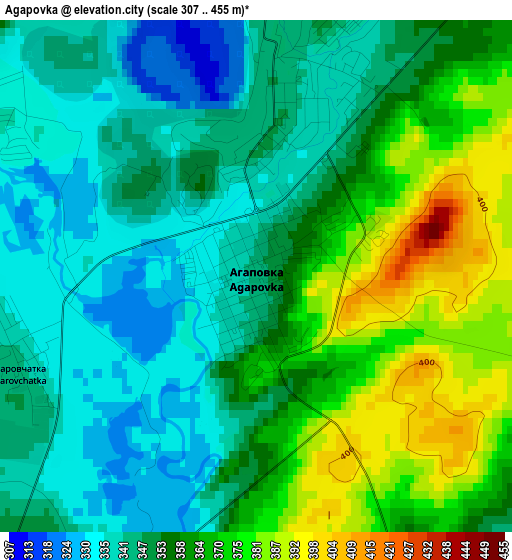
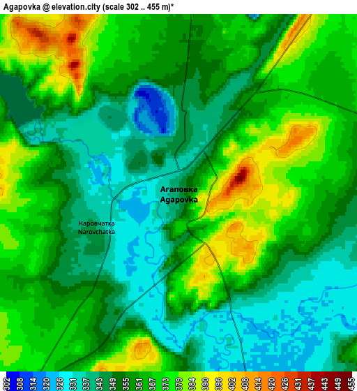
Below is the Elevation map of Agapovka, which displays elevation range with different colors. Scale of the first map is from 307 to 455 m (1007 to 1493 ft) with average elevation of 355.2 meters (=1165 ft) [note 1]
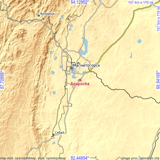
These maps also provides idea of topography and contour of this city, they are displayed at different zoom levels. More info about maps, scale and edge coordinates you can find below images.
| \ | Map #1 | Map #2 | Topo.Map |
| Scale [m] | 307..455 m | 302..455 m | × |
| Scale [ft] | 1007..1493 ft | 991..1493 ft | × |
| Average | 355.2 m = 1165 ft | 358.7 m = 1177 ft | × |
| Width | 5.84 km = 3.6 mi | 11.68 km = 7.3 mi | 186.9 km = 116.1 mi |
| Height | 5.84 km = 3.6 mi | 11.68 km = 7.3 mi | 186.9 km = 116.1 mi |
| ↑Max Latitude | 53.323556° | 53.349797° | 54.12952° |
| Latitude at center | 53.2973° | 53.2973° | 53.2973° |
| ↓Min Latitude | 53.271027° | 53.244739° | 52.44854° |
| ← Min Longitude | 59.090855° | 59.046909° | 57.72855° |
| Longitude center | 59.1348° | 59.1348° | 59.1348° |
| →Max Longitude | 59.178745° | 59.222691° | 60.54105° |
Nearby cities:
Cities around Agapovka sort by population:
• Magnitogorsk elevation 361 m
14.7 km,  336°
336°
• Beloretsk 522 m
88.5 km,  326°
326°
• Sibay 376 m
71.6 km,  205°
205°
• Verkhneural’sk 408 m
64.6 km,  4°
4°
• Mishkino 425 m
78.1 km,  358°
358°
• Fershampenuaz 354 m
51.3 km,  61°
61°
• Abzakovo 515 m
69.1 km, 328°
• Temyasovo 558 m
76.8 km,  243°
243°
• Lomovka 506 m
85.7 km,  323°
323°
• Mindyak 516 m
83.9 km, 344°
• Parizh 377 m
64.2 km,  89°
89°
• Tubinskiy 570 m
76 km,  233°
233°
Multilingual:
 En español:
Agapovka elevación 344 m.
 En France:
Agapovka élévation 344 m.
 Auf Deutsch:
Agapovka höhe über dem Meeresspiegel ist 344 m.

Sources and notes:
- [note 1] Map square and city borders are not equal. Map elevation data is calculated only from area inside that square.
- [src 1] Elevation data from geonames database provided with same terms of usage.
- [src 2] The elevation map of Agapovka is generated using elevation data from NASA's 3 arcsec (90m) resolution SRTM data.
- [src 3] Base (background) map © OpenStreetMap contributors tiles are generated by Geofabrik and OpenTopoMap.
Copyright & License:
This Agapovka Elevation Map is licensed under CC BY-SA. You may reuse any part from this page, if you give a proper credit by linking to this URL:
 More info on terms of use page.