Parizh elevation
Parizh (Chelyabinsk), Russia elevation is 377 meters and Parizh elevation in feet is 1237 ft above sea level [src 1]. Parizh is a populated place (feature code) with elevation that is 178 meters (584 ft) bigger than average city elevation in Russia.
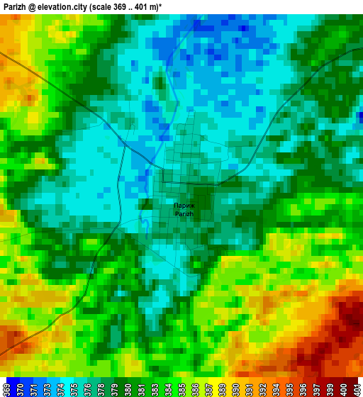
Below is the Elevation map of Parizh, which displays elevation range with different colors. Scale of the first map is from 369 to 401 m (1211 to 1316 ft) with average elevation of 381 meters (=1250 ft) [note 1]
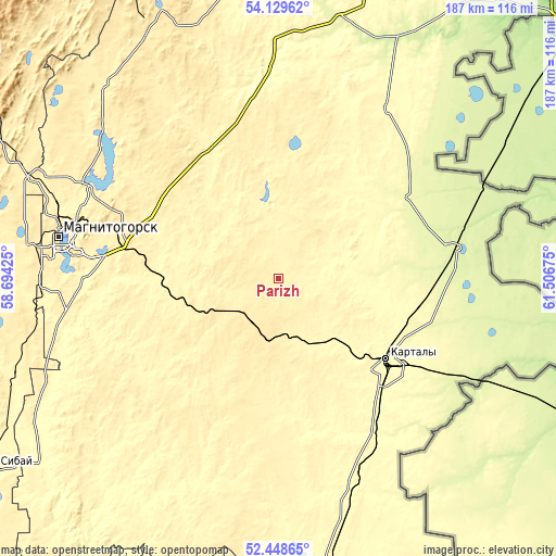
These maps also provides idea of topography and contour of this city, they are displayed at different zoom levels. More info about maps, scale and edge coordinates you can find below images.
| \ | Map #1 | Topo.Map |
| Scale [m] | 369..401 m | × |
| Scale [ft] | 1211..1316 ft | × |
| Average | 381 m = 1250 ft | × |
| Width | 5.84 km = 3.6 mi | 186.9 km = 116.1 mi |
| Height | 5.84 km = 3.6 mi | 186.9 km = 116.1 mi |
| ↑Max Latitude | 53.323656° | 54.12962° |
| Latitude at center | 53.2974° | 53.2974° |
| ↓Min Latitude | 53.271128° | 52.44865° |
| ← Min Longitude | 60.056555° | 58.69425° |
| Longitude center | 60.1005° | 60.1005° |
| →Max Longitude | 60.144445° | 61.50675° |
Nearby cities:
Cities around Parizh sort by population:
• Magnitogorsk elevation 361 m
71.2 km,  280°
280°
• Kartaly 299 m
45.6 km,  126°
126°
• Lokomotivnyy 351 m
44.5 km,  135°
135°
• Bredy 302 m
99.4 km,  170°
170°
• Verkhneural’sk 408 m
87.2 km,  317°
317°
• Varna 250 m
58.8 km,  80°
80°
• Agapovka 344 m
64.2 km,  269°
269°
• Mishkino 425 m
101.9 km, 320°
• Chesma 314 m
67.8 km,  32°
32°
• Fershampenuaz 354 m
31.3 km, 322°
• Akhunovo 359 m
106.4 km,  342°
342°
• Velikopetrovka 328 m
26.2 km,  101°
101°
Multilingual:
 En español:
Parizh elevación 377 m.
 En France:
Parizh élévation 377 m.
 Auf Deutsch:
Paris, Posten № 4 höhe über dem Meeresspiegel ist 377 m.

Sources and notes:
- [note 1] Map square and city borders are not equal. Map elevation data is calculated only from area inside that square.
- [src 1] Elevation data from geonames database provided with same terms of usage.
- [src 2] The elevation map of Parizh is generated using elevation data from NASA's 3 arcsec (90m) resolution SRTM data.
- [src 3] Base (background) map © OpenStreetMap contributors tiles are generated by Geofabrik and OpenTopoMap.
Copyright & License:
This Parizh Elevation Map is licensed under CC BY-SA. You may reuse any part from this page, if you give a proper credit by linking to this URL:
 More info on terms of use page.