Bredy elevation
Bredy (Chelyabinsk), Russia elevation is 302 meters and Bredy elevation in feet is 991 ft above sea level [src 1]. Bredy is a populated place (feature code) with elevation that is 103 meters (338 ft) bigger than average city elevation in Russia.
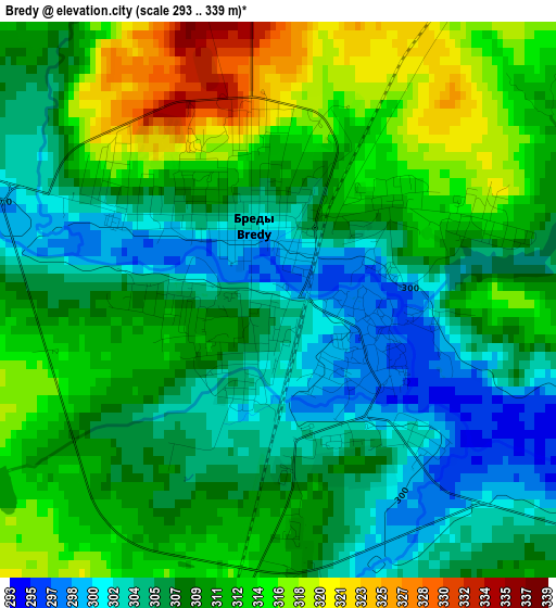
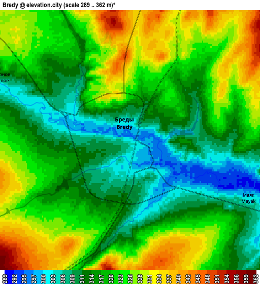
Below is the Elevation map of Bredy, which displays elevation range with different colors. Scale of the first map is from 293 to 339 m (961 to 1112 ft) with average elevation of 309.1 meters (=1014 ft) [note 1]
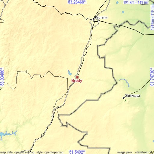
These maps also provides idea of topography and contour of this city, they are displayed at different zoom levels. More info about maps, scale and edge coordinates you can find below images.
| \ | Map #1 | Map #2 | Topo.Map |
| Scale [m] | 293..339 m | 289..362 m | × |
| Scale [ft] | 961..1112 ft | 948..1188 ft | × |
| Average | 309.1 m = 1014 ft | 319.8 m = 1049 ft | × |
| Width | 5.96 km = 3.7 mi | 11.92 km = 7.4 mi | 190.7 km = 118.5 mi |
| Height | 5.96 km = 3.7 mi | 11.92 km = 7.4 mi | 190.7 km = 118.5 mi |
| ↑Max Latitude | 52.442076° | 52.468855° | 53.26468° |
| Latitude at center | 52.41528° | 52.41528° | 52.41528° |
| ↓Min Latitude | 52.388468° | 52.36164° | 51.5492° |
| ← Min Longitude | 60.297165° | 60.253219° | 58.93486° |
| Longitude center | 60.34111° | 60.34111° | 60.34111° |
| →Max Longitude | 60.385055° | 60.429001° | 61.74736° |
Nearby cities:
Cities around Bredy sort by population:
• Sibay elevation 376 m
118.1 km,  286°
286°
• Kartaly 299 m
73.9 km,  16°
16°
• Lokomotivnyy 351 m
68.1 km,  12°
12°
• Varna 250 m
115.6 km, 21°
• Adamovka 284 m
103 km,  195°
195°
• Kvarkeno 281 m
55.9 km,  228°
228°
• Krasnoyarskiy 318 m
58.5 km,  211°
211°
• Parizh 377 m
99.4 km,  350°
350°
• Shil’da 336 m
77.2 km, 210°
• Yelizavetinka 312 m
82.8 km, 209°
• Alandskoye 318 m
42.7 km,  240°
240°
• Velikopetrovka 328 m
93.4 km, 5°
Multilingual:
 En español:
Bredy elevación 302 m.
 En France:
Bredy élévation 302 m.


Sources and notes:
- [note 1] Map square and city borders are not equal. Map elevation data is calculated only from area inside that square.
- [src 1] Elevation data from geonames database provided with same terms of usage.
- [src 2] The elevation map of Bredy is generated using elevation data from NASA's 3 arcsec (90m) resolution SRTM data.
- [src 3] Base (background) map © OpenStreetMap contributors tiles are generated by Geofabrik and OpenTopoMap.
Copyright & License:
This Bredy Elevation Map is licensed under CC BY-SA. You may reuse any part from this page, if you give a proper credit by linking to this URL:
 More info on terms of use page.