Kvarkeno elevation
Kvarkeno (Orenburg Oblast), Russia elevation is 281 meters and Kvarkeno elevation in feet is 922 ft above sea level [src 1]. Kvarkeno is a populated place (feature code) with elevation that is 82 meters (269 ft) bigger than average city elevation in Russia.
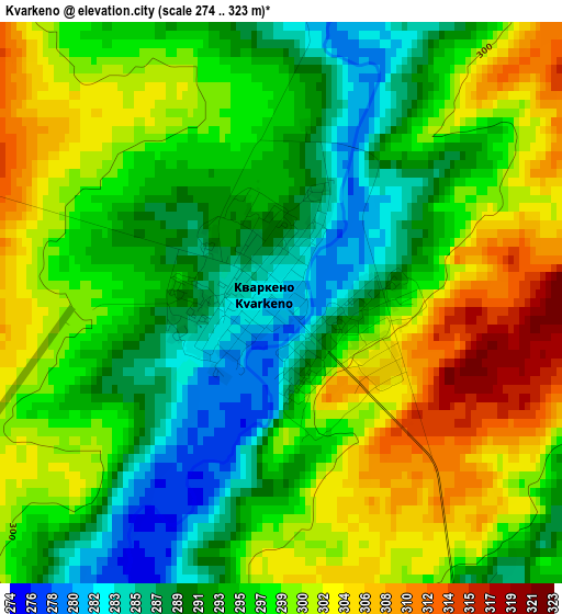
Below is the Elevation map of Kvarkeno, which displays elevation range with different colors. Scale of the first map is from 274 to 323 m (899 to 1060 ft) with average elevation of 296.3 meters (=972 ft) [note 1]
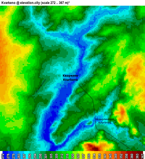
These maps also provides idea of topography and contour of this city, they are displayed at different zoom levels. More info about maps, scale and edge coordinates you can find below images.
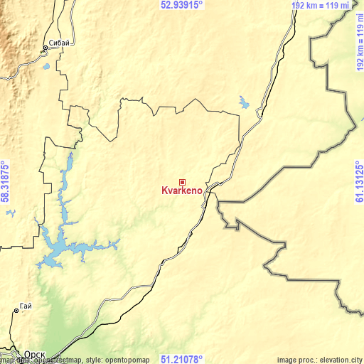
| \ | Map #1 | Map #2 | Topo.Map |
| Scale [m] | 274..323 m | 272..367 m | × |
| Scale [ft] | 899..1060 ft | 892..1204 ft | × |
| Average | 296.3 m = 972 ft | 305.4 m = 1002 ft | × |
| Width | 6.01 km = 3.7 mi | 12.01 km = 7.5 mi | 192.2 km = 119.4 mi |
| Height | 6.01 km = 3.7 mi | 12.01 km = 7.5 mi | 192.2 km = 119.4 mi |
| ↑Max Latitude | 52.110327° | 52.137307° | 52.93915° |
| Latitude at center | 52.08333° | 52.08333° | 52.08333° |
| ↓Min Latitude | 52.056317° | 52.029287° | 51.21078° |
| ← Min Longitude | 59.681055° | 59.637109° | 58.31875° |
| Longitude center | 59.725° | 59.725° | 59.725° |
| →Max Longitude | 59.768945° | 59.812891° | 61.13125° |
Nearby cities:
Cities around Kvarkeno sort by population:
• Sibay elevation 376 m
100.7 km,  314°
314°
• Baymak 502 m
110.9 km,  300°
300°
• Novoorsk 214 m
93.4 km,  213°
213°
• Bredy 302 m
55.9 km,  48°
48°
• Energetik 269 m
74.2 km,  239°
239°
• Adamovka 284 m
64.1 km,  166°
166°
• Ak”yar 330 m
106 km,  256°
256°
• Buribay 337 m
108 km, 262°
• Krasnoyarskiy 318 m
17.6 km,  138°
138°
• Shil’da 336 m
30.1 km, 173°
• Yelizavetinka 312 m
35.2 km,  178°
178°
• Alandskoye 318 m
16.6 km,  16°
16°
Multilingual:
 En español:
Kvarkeno elevación 281 m.
 En France:
Kvarkeno élévation 281 m.
 Auf Deutsch:
Kvarkeno höhe über dem Meeresspiegel ist 281 m.

Sources and notes:
- [note 1] Map square and city borders are not equal. Map elevation data is calculated only from area inside that square.
- [src 1] Elevation data from geonames database provided with same terms of usage.
- [src 2] The elevation map of Kvarkeno is generated using elevation data from NASA's 3 arcsec (90m) resolution SRTM data.
- [src 3] Base (background) map © OpenStreetMap contributors tiles are generated by Geofabrik and OpenTopoMap.
Copyright & License:
This Kvarkeno Elevation Map is licensed under CC BY-SA. You may reuse any part from this page, if you give a proper credit by linking to this URL:
 More info on terms of use page.