Ak”yar elevation
Ak”yar (Bashkortostan Republic), Russia elevation is 330 meters and Ak”yar elevation in feet is 1083 ft above sea level [src 1]. Ak”yar is a populated place (feature code) with elevation that is 131 meters (430 ft) bigger than average city elevation in Russia.
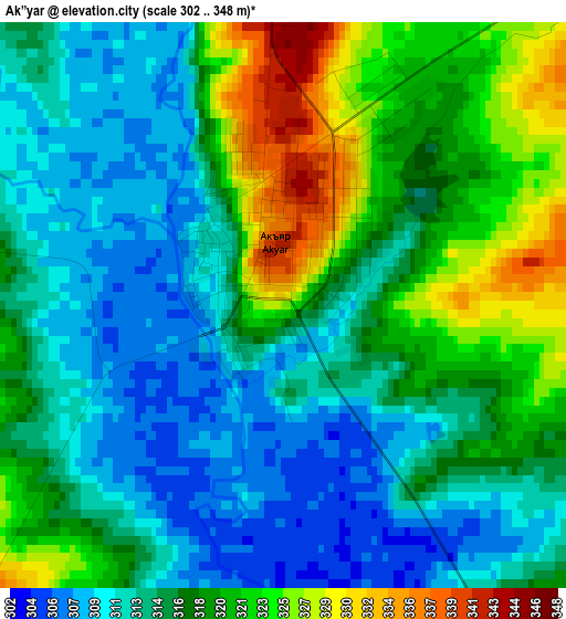
Below is the Elevation map of Ak”yar, which displays elevation range with different colors. Scale of the first map is from 302 to 348 m (991 to 1142 ft) with average elevation of 316.3 meters (=1038 ft) [note 1]
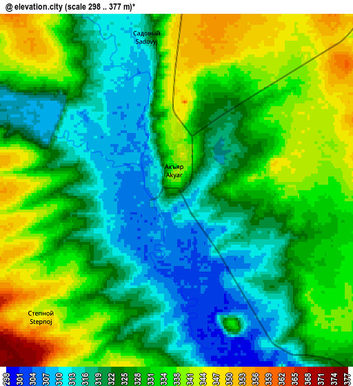
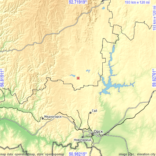
These maps also provides idea of topography and contour of this city, they are displayed at different zoom levels. More info about maps, scale and edge coordinates you can find below images.
| \ | Map #1 | Map #2 | Topo.Map |
| Scale [m] | 302..348 m | 298..377 m | × |
| Scale [ft] | 991..1142 ft | 978..1237 ft | × |
| Average | 316.3 m = 1038 ft | 328.1 m = 1076 ft | × |
| Width | 6.04 km = 3.8 mi | 12.07 km = 7.5 mi | 193.1 km = 120 mi |
| Height | 6.04 km = 3.8 mi | 12.07 km = 7.5 mi | 193.1 km = 120 mi |
| ↑Max Latitude | 51.886182° | 51.913298° | 52.71919° |
| Latitude at center | 51.85905° | 51.85905° | 51.85905° |
| ↓Min Latitude | 51.831901° | 51.804736° | 50.98215° |
| ← Min Longitude | 58.177415° | 58.133469° | 56.81511° |
| Longitude center | 58.22136° | 58.22136° | 58.22136° |
| →Max Longitude | 58.265305° | 58.309251° | 59.62761° |
Nearby cities:
Cities around Ak”yar sort by population:
• Orsk elevation 192 m
76.6 km,  161°
161°
• Novotroitsk 213 m
73.3 km,  174°
174°
• Gay 378 m
46.5 km, 159°
• Mednogorsk 316 m
65.8 km,  221°
221°
• Kuvandyk 211 m
73.2 km,  234°
234°
• Baymak 502 m
81.9 km,  4°
4°
• Novoorsk 214 m
74.7 km,  135°
135°
• Energetik 269 m
41.3 km,  107°
107°
• Zilair 505 m
67.8 km,  307°
307°
• Buribay 337 m
12.2 km,  339°
339°
• Novorudnyy 385 m
39.7 km,  183°
183°
• Staraya Akkermanovka 293 m
68.1 km, 178°
Multilingual:
 En español:
Ak”yar elevación 330 m.
 En France:
Ak”yar élévation 330 m.


Sources and notes:
- [note 1] Map square and city borders are not equal. Map elevation data is calculated only from area inside that square.
- [src 1] Elevation data from geonames database provided with same terms of usage.
- [src 2] The elevation map of Ak”yar is generated using elevation data from NASA's 3 arcsec (90m) resolution SRTM data.
- [src 3] Base (background) map © OpenStreetMap contributors tiles are generated by Geofabrik and OpenTopoMap.
Copyright & License:
This Ak”yar Elevation Map is licensed under CC BY-SA. You may reuse any part from this page, if you give a proper credit by linking to this URL:
 More info on terms of use page.