Zilair elevation
Zilair (Bashkortostan Republic), Russia elevation is 505 meters and Zilair elevation in feet is 1657 ft above sea level [src 1]. Zilair is a populated place (feature code) with elevation that is 306 meters (1004 ft) bigger than average city elevation in Russia.
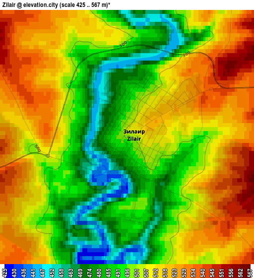
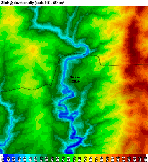
Below is the Elevation map of Zilair, which displays elevation range with different colors. Scale of the first map is from 425 to 567 m (1394 to 1860 ft) with average elevation of 503.9 meters (=1653 ft) [note 1]
These maps also provides idea of topography and contour of this city, they are displayed at different zoom levels. More info about maps, scale and edge coordinates you can find below images.
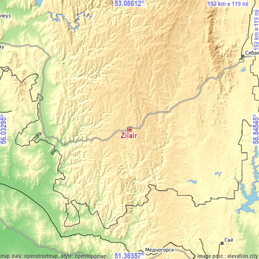
| \ | Map #1 | Map #2 | Topo.Map |
| Scale [m] | 425..567 m | 415..654 m | × |
| Scale [ft] | 1394..1860 ft | 1362..2146 ft | × |
| Average | 503.9 m = 1653 ft | 528.7 m = 1735 ft | × |
| Width | 5.99 km = 3.7 mi | 11.97 km = 7.4 mi | 191.5 km = 119 mi |
| Height | 5.99 km = 3.7 mi | 11.97 km = 7.4 mi | 191.5 km = 119 mi |
| ↑Max Latitude | 52.260106° | 52.286996° | 53.08612° |
| Latitude at center | 52.2332° | 52.2332° | 52.2332° |
| ↓Min Latitude | 52.206278° | 52.179339° | 51.36357° |
| ← Min Longitude | 57.395255° | 57.351309° | 56.03295° |
| Longitude center | 57.4392° | 57.4392° | 57.4392° |
| →Max Longitude | 57.483145° | 57.527091° | 58.84545° |
Nearby cities:
Cities around Zilair sort by population:
• Mednogorsk elevation 316 m
91.8 km,  173°
173°
• Kuvandyk 211 m
84.2 km,  183°
183°
• Baymak 502 m
72.1 km,  56°
56°
• Saraktash 142 m
88.9 km,  236°
236°
• Tyul’gan 308 m
87.4 km,  277°
277°
• Mrakovo 231 m
77 km,  314°
314°
• Isyangulovo 184 m
58.7 km,  264°
264°
• Ak”yar 330 m
67.8 km,  127°
127°
• Buribay 337 m
57.7 km,  121°
121°
• Temyasovo 558 m
95.6 km,  27°
27°
• Matveyevka 185 m
86.1 km, 263°
• Tubinskiy 570 m
90.1 km,  35°
35°
Multilingual:
 En español:
Zilair elevación 505 m.
 En France:
Zilair élévation 505 m.


Sources and notes:
- [note 1] Map square and city borders are not equal. Map elevation data is calculated only from area inside that square.
- [src 1] Elevation data from geonames database provided with same terms of usage.
- [src 2] The elevation map of Zilair is generated using elevation data from NASA's 3 arcsec (90m) resolution SRTM data.
- [src 3] Base (background) map © OpenStreetMap contributors tiles are generated by Geofabrik and OpenTopoMap.
Copyright & License:
This Zilair Elevation Map is licensed under CC BY-SA. You may reuse any part from this page, if you give a proper credit by linking to this URL:
 More info on terms of use page.