Saraktash elevation
Saraktash (Orenburg Oblast), Russia elevation is 142 meters and Saraktash elevation in feet is 466 ft above sea level [src 1]. Saraktash is a populated place (feature code) with elevation that is 57 meters (187 ft) smaller than average city elevation in Russia.
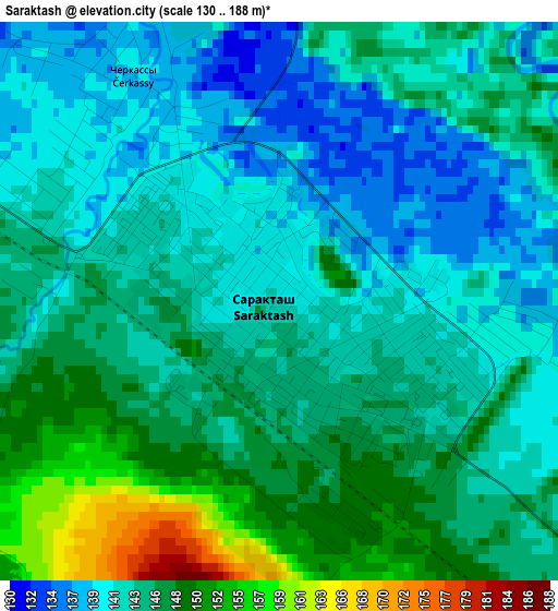
Below is the Elevation map of Saraktash, which displays elevation range with different colors. Scale of the first map is from 130 to 188 m (427 to 617 ft) with average elevation of 144.2 meters (=473 ft) [note 1]
These maps also provides idea of topography and contour of this city, they are displayed at different zoom levels. More info about maps, scale and edge coordinates you can find below images.
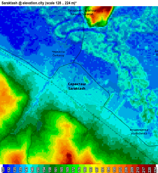
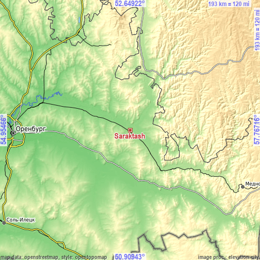
| \ | Map #1 | Map #2 | Topo.Map |
| Scale [m] | 130..188 m | 128..224 m | × |
| Scale [ft] | 427..617 ft | 420..735 ft | × |
| Average | 144.2 m = 473 ft | 150.8 m = 495 ft | × |
| Width | 6.05 km = 3.8 mi | 12.09 km = 7.5 mi | 193.4 km = 120.2 mi |
| Height | 6.05 km = 3.8 mi | 12.09 km = 7.5 mi | 193.4 km = 120.2 mi |
| ↑Max Latitude | 51.814885° | 51.842044° | 52.64922° |
| Latitude at center | 51.78771° | 51.78771° | 51.78771° |
| ↓Min Latitude | 51.760518° | 51.73331° | 50.90943° |
| ← Min Longitude | 56.316965° | 56.273019° | 54.95466° |
| Longitude center | 56.36091° | 56.36091° | 56.36091° |
| →Max Longitude | 56.404855° | 56.448801° | 57.76716° |
Nearby cities:
Cities around Saraktash sort by population:
• Orenburg elevation 107 m
86.8 km,  268°
268°
• Kuvandyk 211 m
76.8 km,  116°
116°
• Tyul’gan 308 m
62.9 km,  347°
347°
• Isyangulovo 184 m
46.8 km,  18°
18°
• Zilair 505 m
88.9 km,  56°
56°
• Belyayevka 128 m
43.6 km,  174°
174°
• Nezhinka 100 m
68.2 km, 268°
• Sakmara 111 m
73.8 km,  287°
287°
• Krasnyy Kommunar 105 m
71 km, 286°
• Tatarskaya Kargala 105 m
83.5 km,  282°
282°
• Matveyevka 185 m
42.1 km,  343°
343°
• Prigorodnyy 98 m
75.3 km, 268°
Multilingual:
 En español:
Saraktash elevación 142 m.
 En France:
Saraktash élévation 142 m.
 Auf Deutsch:
Saraktash höhe über dem Meeresspiegel ist 142 m.

Sources and notes:
- [note 1] Map square and city borders are not equal. Map elevation data is calculated only from area inside that square.
- [src 1] Elevation data from geonames database provided with same terms of usage.
- [src 2] The elevation map of Saraktash is generated using elevation data from NASA's 3 arcsec (90m) resolution SRTM data.
- [src 3] Base (background) map © OpenStreetMap contributors tiles are generated by Geofabrik and OpenTopoMap.
Copyright & License:
This Saraktash Elevation Map is licensed under CC BY-SA. You may reuse any part from this page, if you give a proper credit by linking to this URL:
 More info on terms of use page.