Kuvandyk elevation
Kuvandyk (Orenburg Oblast), Russia elevation is 211 meters and Kuvandyk elevation in feet is 692 ft above sea level [src 1]. Kuvandyk is a populated place (feature code) with elevation that is 12 meters (39 ft) bigger than average city elevation in Russia.
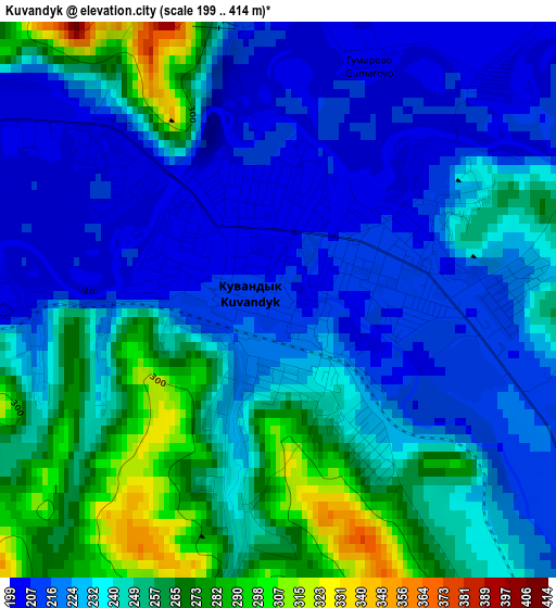
Below is the Elevation map of Kuvandyk, which displays elevation range with different colors. Scale of the first map is from 199 to 414 m (653 to 1358 ft) with average elevation of 237.6 meters (=780 ft) [note 1]
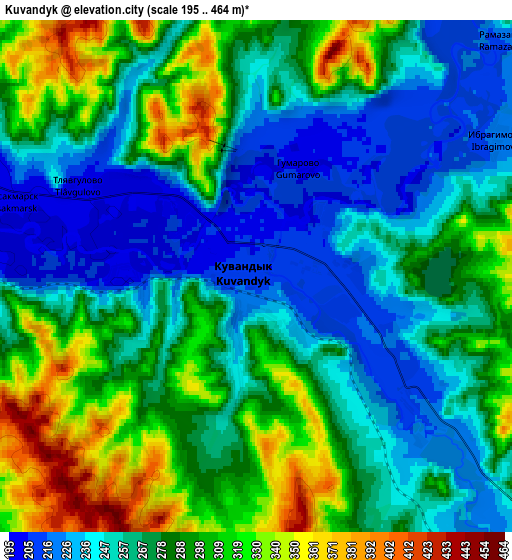
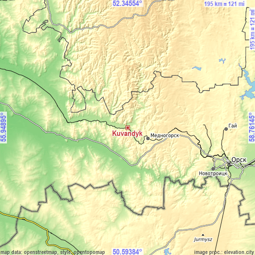
These maps also provides idea of topography and contour of this city, they are displayed at different zoom levels. More info about maps, scale and edge coordinates you can find below images.
| \ | Map #1 | Map #2 | Topo.Map |
| Scale [m] | 199..414 m | 195..464 m | × |
| Scale [ft] | 653..1358 ft | 640..1522 ft | × |
| Average | 237.6 m = 780 ft | 275.6 m = 904 ft | × |
| Width | 6.09 km = 3.8 mi | 12.17 km = 7.6 mi | 194.8 km = 121 mi |
| Height | 6.09 km = 3.8 mi | 12.17 km = 7.6 mi | 194.8 km = 121 mi |
| ↑Max Latitude | 51.505462° | 51.532807° | 52.34554° |
| Latitude at center | 51.4781° | 51.4781° | 51.4781° |
| ↓Min Latitude | 51.450722° | 51.423328° | 50.59384° |
| ← Min Longitude | 57.311255° | 57.267309° | 55.94895° |
| Longitude center | 57.3552° | 57.3552° | 57.3552° |
| →Max Longitude | 57.399145° | 57.443091° | 58.76145° |
Nearby cities:
Cities around Kuvandyk sort by population:
• Orsk elevation 192 m
89.5 km,  109°
109°
• Novotroitsk 213 m
74.1 km, 114°
• Gay 378 m
76.2 km,  90°
90°
• Mednogorsk 316 m
18.1 km, 113°
• Saraktash 142 m
76.8 km,  296°
296°
• Isyangulovo 184 m
95 km,  325°
325°
• Zilair 505 m
84.2 km,  3°
3°
• Ak”yar 330 m
73.2 km,  54°
54°
• Belyayevka 128 m
65.7 km,  262°
262°
• Buribay 337 m
77.2 km, 45°
• Novorudnyy 385 m
57.7 km, 87°
• Staraya Akkermanovka 293 m
66.5 km, 112°
Multilingual:
 En español:
Kuvandyk elevación 211 m.
 En France:
Kouvandyk élévation 211 m.
 Auf Deutsch:
Kuwandyk höhe über dem Meeresspiegel ist 211 m.

Sources and notes:
- [note 1] Map square and city borders are not equal. Map elevation data is calculated only from area inside that square.
- [src 1] Elevation data from geonames database provided with same terms of usage.
- [src 2] The elevation map of Kuvandyk is generated using elevation data from NASA's 3 arcsec (90m) resolution SRTM data.
- [src 3] Base (background) map © OpenStreetMap contributors tiles are generated by Geofabrik and OpenTopoMap.
Copyright & License:
This Kuvandyk Elevation Map is licensed under CC BY-SA. You may reuse any part from this page, if you give a proper credit by linking to this URL:
 More info on terms of use page.