Băceşti elevation
Băceşti (Vaslui, Comuna Băceşti), Romania elevation is 153 meters and Băceşti elevation in feet is 502 ft above sea level [src 1]. Băceşti is a seat of a second-order administrative division (feature code) with elevation that is 99 meters (325 ft) smaller than average city elevation in Romania.
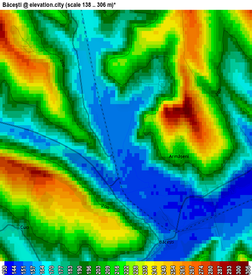
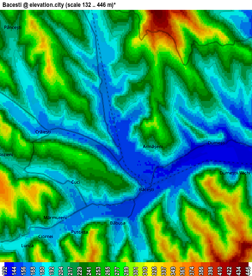
Below is the Elevation map of Băceşti, which displays elevation range with different colors. Scale of the first map is from 138 to 306 m (453 to 1004 ft) with average elevation of 196.9 meters (=646 ft) [note 1]
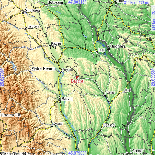
These maps also provides idea of topography and contour of this city, they are displayed at different zoom levels. More info about maps, scale and edge coordinates you can find below images.
| \ | Map #1 | Map #2 | Topo.Map |
| Scale [m] | 138..306 m | 132..446 m | × |
| Scale [ft] | 453..1004 ft | 433..1463 ft | × |
| Average | 196.9 m = 646 ft | 228.7 m = 750 ft | × |
| Width | 6.68 km = 4.2 mi | 13.37 km = 8.3 mi | 213.9 km = 132.9 mi |
| Height | 6.68 km = 4.2 mi | 13.37 km = 8.3 mi | 213.9 km = 132.9 mi |
| ↑Max Latitude | 46.880046° | 46.910076° | 47.80315° |
| Latitude at center | 46.85° | 46.85° | 46.85° |
| ↓Min Latitude | 46.819937° | 46.789857° | 45.87963° |
| ← Min Longitude | 27.189385° | 27.145439° | 25.82708° |
| Longitude center | 27.23333° | 27.23333° | 27.23333° |
| →Max Longitude | 27.277275° | 27.321221° | 28.63958° |
Nearby cities:
Cities around Băceşti sort by population:
• Ţibăneşti elevation 150 m
10.6 km,  45°
45°
• Todireşti 183 m
10.1 km,  90°
90°
• Poienile 196 m
10 km,  337°
337°
• Dumeşti 216 m
3.8 km, 90°
• Oniceni 334 m
7.3 km,  239°
239°
• Poienari 235 m
9.1 km,  297°
297°
• Tansa 319 m
7.4 km,  0°
0°
• Bozieni 272 m
6.6 km,  253°
253°
• Gârceni 389 m
10 km,  157°
157°
• Suhuleț 423 m
6.3 km,  17°
17°
• Dagâţa 196 m
10 km, 337°
• Pânceşti 237 m
8.5 km,  314°
314°
Multilingual:
 En español:
Băceşti elevación 153 m.
 En France:
Băceşti élévation 153 m.


Sources and notes:
- [note 1] Map square and city borders are not equal. Map elevation data is calculated only from area inside that square.
- [src 1] Elevation data from geonames database provided with same terms of usage.
- [src 2] The elevation map of Băceşti is generated using elevation data from NASA's 3 arcsec (90m) resolution SRTM data.
- [src 3] Base (background) map © OpenStreetMap contributors tiles are generated by Geofabrik and OpenTopoMap.
Copyright & License:
This Băceşti Elevation Map is licensed under CC BY-SA. You may reuse any part from this page, if you give a proper credit by linking to this URL:
 More info on terms of use page.