Gârceni elevation
Gârceni (Vaslui, Comuna Gârceni), Romania elevation is 389 meters and Gârceni elevation in feet is 1276 ft above sea level [src 1]. Gârceni is a seat of a second-order administrative division (feature code) with elevation that is 137 meters (449 ft) bigger than average city elevation in Romania.
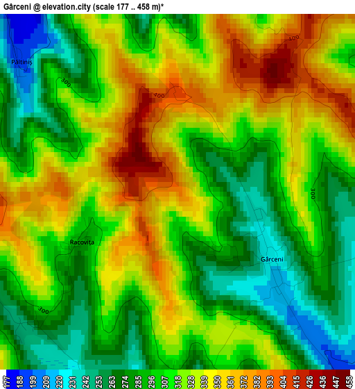
Below is the Elevation map of Gârceni, which displays elevation range with different colors. Scale of the first map is from 177 to 458 m (581 to 1503 ft) with average elevation of 313.6 meters (=1029 ft) [note 1]
These maps also provides idea of topography and contour of this city, they are displayed at different zoom levels. More info about maps, scale and edge coordinates you can find below images.
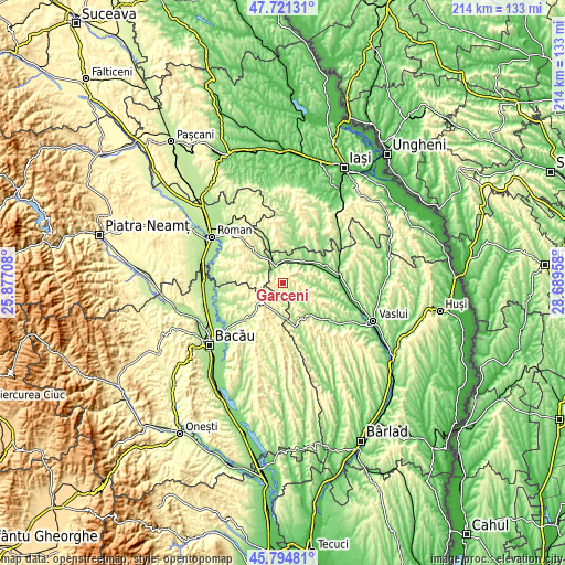
| \ | Map #1 | Topo.Map |
| Scale [m] | 177..458 m | × |
| Scale [ft] | 581..1503 ft | × |
| Average | 313.6 m = 1029 ft | × |
| Width | 6.69 km = 4.2 mi | 214.2 km = 133.1 mi |
| Height | 6.69 km = 4.2 mi | 214.2 km = 133.1 mi |
| ↑Max Latitude | 46.796763° | 47.72131° |
| Latitude at center | 46.76667° | 46.76667° |
| ↓Min Latitude | 46.73656° | 45.79481° |
| ← Min Longitude | 27.239385° | 25.87708° |
| Longitude center | 27.28333° | 27.28333° |
| →Max Longitude | 27.327275° | 28.68958° |
Nearby cities:
Cities around Gârceni sort by population:
• Negreşti elevation 119 m
13.6 km,  57°
57°
• Todireşti 183 m
11.2 km,  34°
34°
• Băceşti 153 m
10 km,  337°
337°
• Dumeşti 216 m
9.3 km,  0°
0°
• Pungeşti 253 m
8.3 km,  152°
152°
• Plopana 231 m
10.6 km,  208°
208°
• Oniceni 334 m
11.6 km,  298°
298°
• Bozieni 272 m
12.6 km,  306°
306°
• Lipova 246 m
6.7 km, 214°
• Rafaila 312 m
7.1 km, 57°
• Buda 157 m
10.5 km,  92°
92°
• Fâstâci 218 m
13.2 km,  107°
107°
Multilingual:
 En español:
Gârceni elevación 389 m.
 En France:
Gârceni élévation 389 m.


Sources and notes:
- [note 1] Map square and city borders are not equal. Map elevation data is calculated only from area inside that square.
- [src 1] Elevation data from geonames database provided with same terms of usage.
- [src 2] The elevation map of Gârceni is generated using elevation data from NASA's 3 arcsec (90m) resolution SRTM data.
- [src 3] Base (background) map © OpenStreetMap contributors tiles are generated by Geofabrik and OpenTopoMap.
Copyright & License:
This Gârceni Elevation Map is licensed under CC BY-SA. You may reuse any part from this page, if you give a proper credit by linking to this URL:
 More info on terms of use page.