Plopana elevation
Plopana (Bacău, Comuna Plopana), Romania elevation is 231 meters and Plopana elevation in feet is 758 ft above sea level [src 1]. Plopana is a seat of a second-order administrative division (feature code) with elevation that is 21 meters (69 ft) smaller than average city elevation in Romania.
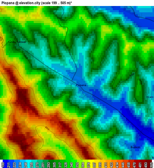
Below is the Elevation map of Plopana, which displays elevation range with different colors. Scale of the first map is from 199 to 505 m (653 to 1657 ft) with average elevation of 322.2 meters (=1057 ft) [note 1]
These maps also provides idea of topography and contour of this city, they are displayed at different zoom levels. More info about maps, scale and edge coordinates you can find below images.
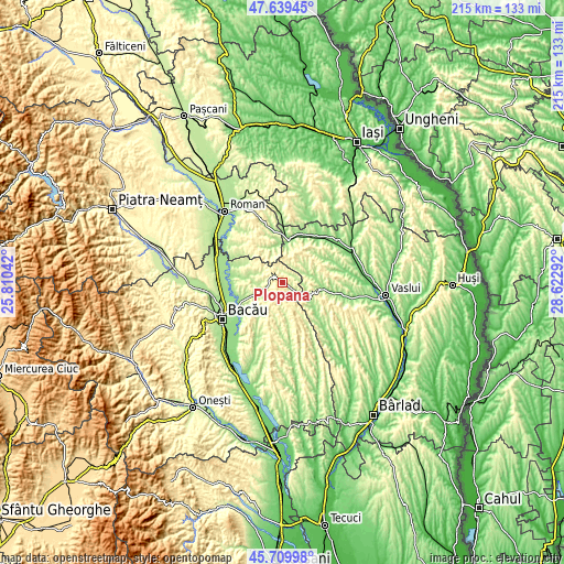
| \ | Map #1 | Topo.Map |
| Scale [m] | 199..505 m | × |
| Scale [ft] | 653..1657 ft | × |
| Average | 322.2 m = 1057 ft | × |
| Width | 6.7 km = 4.2 mi | 214.5 km = 133.3 mi |
| Height | 6.7 km = 4.2 mi | 214.5 km = 133.3 mi |
| ↑Max Latitude | 46.713469° | 47.63945° |
| Latitude at center | 46.68333° | 46.68333° |
| ↓Min Latitude | 46.653174° | 45.70998° |
| ← Min Longitude | 27.172725° | 25.81042° |
| Longitude center | 27.21667° | 27.21667° |
| →Max Longitude | 27.260615° | 28.62292° |
Nearby cities:
Cities around Plopana sort by population:
• Dragomireşti elevation 212 m
11.6 km,  118°
118°
• Traian 205 m
15.1 km,  248°
248°
• Secuieni 297 m
9.6 km, 247°
• Pungeşti 253 m
9.1 km,  78°
78°
• Oniceni 334 m
15.7 km,  341°
341°
• Lipova 246 m
3.9 km,  18°
18°
• Gârceni 389 m
10.6 km,  28°
28°
• Coloneşti 332 m
14.4 km,  153°
153°
• Roşiori 232 m
10.8 km,  290°
290°
• Izvoru Berheciului 234 m
11.1 km,  180°
180°
• Poiana 197 m
15.3 km,  276°
276°
• Odobești 265 m
5.2 km,  261°
261°
Multilingual:
 En español:
Plopana elevación 231 m.
 En France:
Plopana élévation 231 m.


Sources and notes:
- [note 1] Map square and city borders are not equal. Map elevation data is calculated only from area inside that square.
- [src 1] Elevation data from geonames database provided with same terms of usage.
- [src 2] The elevation map of Plopana is generated using elevation data from NASA's 3 arcsec (90m) resolution SRTM data.
- [src 3] Base (background) map © OpenStreetMap contributors tiles are generated by Geofabrik and OpenTopoMap.
Copyright & License:
This Plopana Elevation Map is licensed under CC BY-SA. You may reuse any part from this page, if you give a proper credit by linking to this URL:
 More info on terms of use page.