Coloneşti elevation
Coloneşti (Bacău, Comuna Coloneşti), Romania elevation is 332 meters and Coloneşti elevation in feet is 1089 ft above sea level [src 1]. Coloneşti is a seat of a second-order administrative division (feature code) with elevation that is 80 meters (262 ft) bigger than average city elevation in Romania.
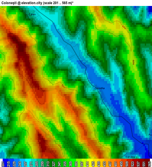
Below is the Elevation map of Coloneşti, which displays elevation range with different colors. Scale of the first map is from 201 to 565 m (659 to 1854 ft) with average elevation of 357.4 meters (=1173 ft) [note 1]
These maps also provides idea of topography and contour of this city, they are displayed at different zoom levels. More info about maps, scale and edge coordinates you can find below images.
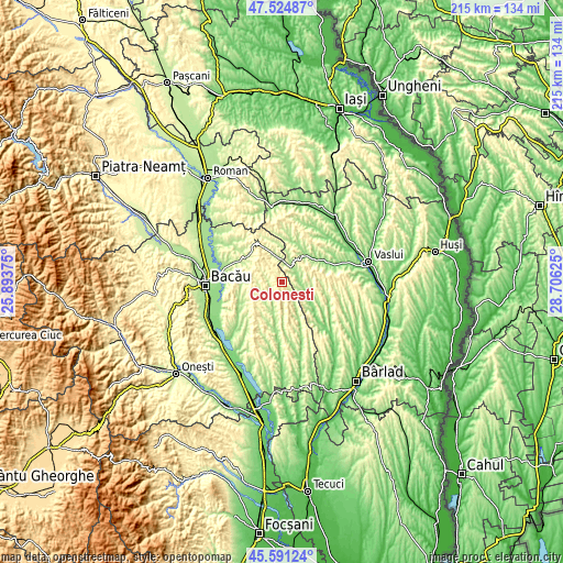
| \ | Map #1 | Topo.Map |
| Scale [m] | 201..565 m | × |
| Scale [ft] | 659..1854 ft | × |
| Average | 357.4 m = 1173 ft | × |
| Width | 6.72 km = 4.2 mi | 215 km = 133.6 mi |
| Height | 6.72 km = 4.2 mi | 215 km = 133.6 mi |
| ↑Max Latitude | 46.596874° | 47.52487° |
| Latitude at center | 46.56667° | 46.56667° |
| ↓Min Latitude | 46.536449° | 45.59124° |
| ← Min Longitude | 27.256055° | 25.89375° |
| Longitude center | 27.3° | 27.3° |
| →Max Longitude | 27.343945° | 28.70625° |
Nearby cities:
Cities around Coloneşti sort by population:
• Răchitoasa elevation 337 m
15.7 km,  161°
161°
• Dragomireşti 212 m
8.3 km,  27°
27°
• Stănişeşti 239 m
14.8 km,  180°
180°
• Voineşti 214 m
8.9 km,  90°
90°
• Pungeşti 253 m
15 km,  9°
9°
• Plopana 231 m
14.4 km,  333°
333°
• Filipeni 292 m
9.7 km,  247°
247°
• Slobozia 261 m
10.2 km, 175°
• Izvoru Berheciului 234 m
6.6 km,  286°
286°
• Onceşti 172 m
11.8 km,  198°
198°
• Ivănești 177 m
14.4 km,  58°
58°
• Ungureni 225 m
15.2 km, 251°
Multilingual:
 En español:
Coloneşti elevación 332 m.
 En France:
Coloneşti élévation 332 m.
 Auf Deutsch:
Coloneşti höhe über dem Meeresspiegel ist 332 m.

Sources and notes:
- [note 1] Map square and city borders are not equal. Map elevation data is calculated only from area inside that square.
- [src 1] Elevation data from geonames database provided with same terms of usage.
- [src 2] The elevation map of Coloneşti is generated using elevation data from NASA's 3 arcsec (90m) resolution SRTM data.
- [src 3] Base (background) map © OpenStreetMap contributors tiles are generated by Geofabrik and OpenTopoMap.
Copyright & License:
This Coloneşti Elevation Map is licensed under CC BY-SA. You may reuse any part from this page, if you give a proper credit by linking to this URL:
 More info on terms of use page.