Răchitoasa elevation
Răchitoasa (Bacău, Comuna Răchitoasa), Romania elevation is 337 meters and Răchitoasa elevation in feet is 1106 ft above sea level [src 1]. Răchitoasa is a seat of a second-order administrative division (feature code) with elevation that is 85 meters (279 ft) bigger than average city elevation in Romania.
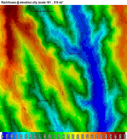
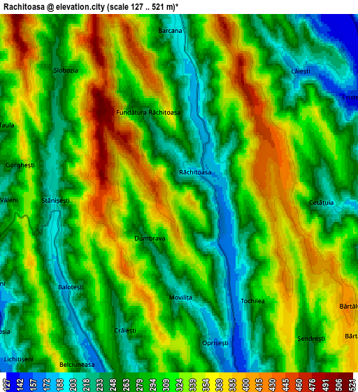
Below is the Elevation map of Răchitoasa, which displays elevation range with different colors. Scale of the first map is from 161 to 519 m (528 to 1703 ft) with average elevation of 313 meters (=1027 ft) [note 1]
These maps also provides idea of topography and contour of this city, they are displayed at different zoom levels. More info about maps, scale and edge coordinates you can find below images.
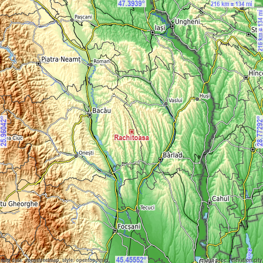
| \ | Map #1 | Map #2 | Topo.Map |
| Scale [m] | 161..519 m | 127..521 m | × |
| Scale [ft] | 528..1703 ft | 417..1709 ft | × |
| Average | 313 m = 1027 ft | 299.9 m = 984 ft | × |
| Width | 6.74 km = 4.2 mi | 13.47 km = 8.4 mi | 215.5 km = 133.9 mi |
| Height | 6.74 km = 4.2 mi | 13.47 km = 8.4 mi | 215.5 km = 133.9 mi |
| ↑Max Latitude | 46.463609° | 46.49387° | 47.3939° |
| Latitude at center | 46.43333° | 46.43333° | 46.43333° |
| ↓Min Latitude | 46.403035° | 46.372722° | 45.45552° |
| ← Min Longitude | 27.322725° | 27.278779° | 25.96042° |
| Longitude center | 27.36667° | 27.36667° | 27.36667° |
| →Max Longitude | 27.410615° | 27.454561° | 28.77292° |
Nearby cities:
Cities around Răchitoasa sort by population:
• Puieşti elevation 116 m
10.4 km,  100°
100°
• Stănişeşti 239 m
5.1 km,  270°
270°
• Motoşeni 234 m
11.2 km,  173°
173°
• Iana 105 m
15.1 km,  111°
111°
• Voineşti 214 m
15.3 km,  14°
14°
• Găiceana 189 m
16 km,  225°
225°
• Ghergheşti 246 m
13.7 km,  57°
57°
• Vultureni 142 m
9.8 km,  220°
220°
• Coloneşti 332 m
15.7 km,  341°
341°
• Slobozia 261 m
6.3 km,  317°
317°
• Onceşti 172 m
9.7 km,  292°
292°
• Hălărești 194 m
15.2 km, 106°
Multilingual:
 En español:
Răchitoasa elevación 337 m.
 En France:
Răchitoasa élévation 337 m.
 Auf Deutsch:
Răchitoasa höhe über dem Meeresspiegel ist 337 m.

Sources and notes:
- [note 1] Map square and city borders are not equal. Map elevation data is calculated only from area inside that square.
- [src 1] Elevation data from geonames database provided with same terms of usage.
- [src 2] The elevation map of Răchitoasa is generated using elevation data from NASA's 3 arcsec (90m) resolution SRTM data.
- [src 3] Base (background) map © OpenStreetMap contributors tiles are generated by Geofabrik and OpenTopoMap.
Copyright & License:
This Răchitoasa Elevation Map is licensed under CC BY-SA. You may reuse any part from this page, if you give a proper credit by linking to this URL:
 More info on terms of use page.