Fâstâci elevation
Fâstâci (Vaslui, Comuna Cozmeşti), Romania elevation is 218 meters and Fâstâci elevation in feet is 715 ft above sea level [src 1]. Fâstâci is a populated place (feature code) with elevation that is 34 meters (112 ft) smaller than average city elevation in Romania.
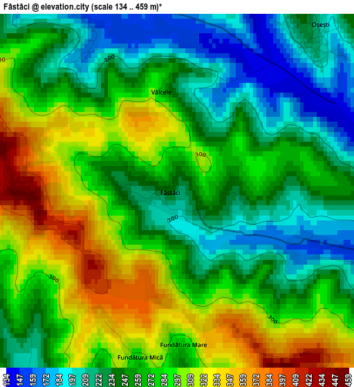
Below is the Elevation map of Fâstâci, which displays elevation range with different colors. Scale of the first map is from 134 to 459 m (440 to 1506 ft) with average elevation of 264.8 meters (=869 ft) [note 1]
These maps also provides idea of topography and contour of this city, they are displayed at different zoom levels. More info about maps, scale and edge coordinates you can find below images.
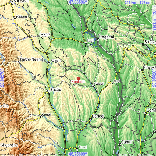
| \ | Map #1 | Topo.Map |
| Scale [m] | 134..459 m | × |
| Scale [ft] | 440..1506 ft | × |
| Average | 264.8 m = 869 ft | × |
| Width | 6.7 km = 4.2 mi | 214.3 km = 133.2 mi |
| Height | 6.7 km = 4.2 mi | 214.3 km = 133.2 mi |
| ↑Max Latitude | 46.760693° | 47.68586° |
| Latitude at center | 46.73058° | 46.73058° |
| ↓Min Latitude | 46.70045° | 45.75808° |
| ← Min Longitude | 27.405065° | 26.04276° |
| Longitude center | 27.44901° | 27.44901° |
| →Max Longitude | 27.492955° | 28.85526° |
Nearby cities:
Cities around Fâstâci sort by population:
• Negreşti elevation 119 m
11.5 km,  354°
354°
• Deleşti 216 m
8.4 km,  113°
113°
• Dragomireşti 212 m
13.2 km,  214°
214°
• Pungeşti 253 m
9.5 km,  248°
248°
• Oşeşti 178 m
4.2 km,  18°
18°
• Gârceni 389 m
13.2 km,  287°
287°
• Vultureşti 157 m
11.5 km,  33°
33°
• Rafaila 312 m
10.2 km,  319°
319°
• Ivănești 177 m
10.7 km,  175°
175°
• Buda 157 m
4.1 km,  328°
328°
• Bârzești 190 m
8 km,  74°
74°
• Cozmești 134 m
4 km,  84°
84°
Multilingual:
 En español:
Fâstâci elevación 218 m.
 En France:
Fâstâci élévation 218 m.


Sources and notes:
- [note 1] Map square and city borders are not equal. Map elevation data is calculated only from area inside that square.
- [src 1] Elevation data from geonames database provided with same terms of usage.
- [src 2] The elevation map of Fâstâci is generated using elevation data from NASA's 3 arcsec (90m) resolution SRTM data.
- [src 3] Base (background) map © OpenStreetMap contributors tiles are generated by Geofabrik and OpenTopoMap.
Copyright & License:
This Fâstâci Elevation Map is licensed under CC BY-SA. You may reuse any part from this page, if you give a proper credit by linking to this URL:
 More info on terms of use page.