Balş elevation
Balş (Olt, Oraş Balş), Romania elevation is 133 meters and Balş elevation in feet is 436 ft above sea level [src 1]. Balş is a seat of a second-order administrative division (feature code) with elevation that is 119 meters (390 ft) smaller than average city elevation in Romania.
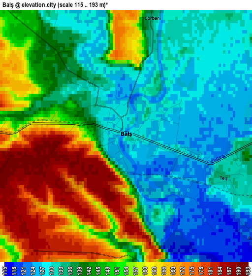
Below is the Elevation map of Balş, which displays elevation range with different colors. Scale of the first map is from 115 to 193 m (377 to 633 ft) with average elevation of 144.6 meters (=474 ft) [note 1]
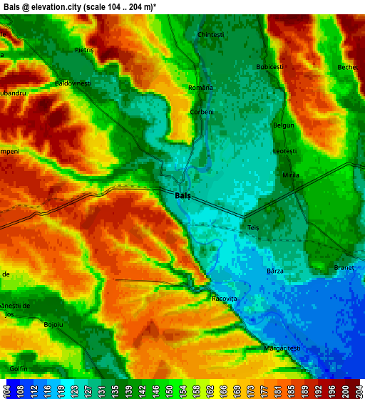
These maps also provides idea of topography and contour of this city, they are displayed at different zoom levels. More info about maps, scale and edge coordinates you can find below images.
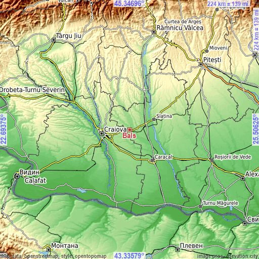
| \ | Map #1 | Map #2 | Topo.Map |
| Scale [m] | 115..193 m | 104..204 m | × |
| Scale [ft] | 377..633 ft | 341..669 ft | × |
| Average | 144.6 m = 474 ft | 152.6 m = 501 ft | × |
| Width | 6.99 km = 4.3 mi | 13.98 km = 8.7 mi | 223.6 km = 138.9 mi |
| Height | 6.99 km = 4.3 mi | 13.98 km = 8.7 mi | 223.6 km = 138.9 mi |
| ↑Max Latitude | 44.381416° | 44.412815° | 45.34696° |
| Latitude at center | 44.35° | 44.35° | 44.35° |
| ↓Min Latitude | 44.318567° | 44.287117° | 43.33579° |
| ← Min Longitude | 24.056055° | 24.012109° | 22.69375° |
| Longitude center | 24.1° | 24.1° | 24.1° |
| →Max Longitude | 24.143945° | 24.187891° | 25.50625° |
Nearby cities:
Cities around Balş sort by population:
• Pieleştí elevation 162 m
12.1 km,  261°
261°
• Oboga 140 m
7.4 km,  0°
0°
• Bobiceşti 151 m
5.4 km,  47°
47°
• Baldovineşti 157 m
5.4 km,  312°
312°
• Drăgoteşti 122 m
11.1 km,  180°
180°
• Voineasa 171 m
7.9 km,  160°
160°
• Braneț 132 m
6.8 km,  113°
113°
• Călui 158 m
11.8 km,  345°
345°
• Olari 133 m
9.8 km,  118°
118°
• Bârza 119 m
4.1 km,  126°
126°
• Găvănești 141 m
10 km,  318°
318°
• Pârşcoveni 134 m
12 km, 117°
Multilingual:
 En español:
Balş elevación 133 m.
 En France:
Balş élévation 133 m.


Sources and notes:
- [note 1] Map square and city borders are not equal. Map elevation data is calculated only from area inside that square.
- [src 1] Elevation data from geonames database provided with same terms of usage.
- [src 2] The elevation map of Balş is generated using elevation data from NASA's 3 arcsec (90m) resolution SRTM data.
- [src 3] Base (background) map © OpenStreetMap contributors tiles are generated by Geofabrik and OpenTopoMap.
Copyright & License:
This Balş Elevation Map is licensed under CC BY-SA. You may reuse any part from this page, if you give a proper credit by linking to this URL:
 More info on terms of use page.