Pârşcoveni elevation
Pârşcoveni (Olt, Comuna Pârşcoveni), Romania elevation is 134 meters and Pârşcoveni elevation in feet is 440 ft above sea level [src 1]. Pârşcoveni is a seat of a second-order administrative division (feature code) with elevation that is 118 meters (387 ft) smaller than average city elevation in Romania.
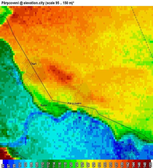
Below is the Elevation map of Pârşcoveni, which displays elevation range with different colors. Scale of the first map is from 95 to 150 m (312 to 492 ft) with average elevation of 122.7 meters (=403 ft) [note 1]
These maps also provides idea of topography and contour of this city, they are displayed at different zoom levels. More info about maps, scale and edge coordinates you can find below images.
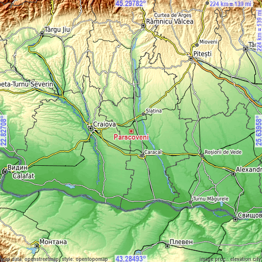
| \ | Map #1 | Topo.Map |
| Scale [m] | 95..150 m | × |
| Scale [ft] | 312..492 ft | × |
| Average | 122.7 m = 403 ft | × |
| Width | 6.99 km = 4.3 mi | 223.8 km = 139.1 mi |
| Height | 6.99 km = 4.3 mi | 223.8 km = 139.1 mi |
| ↑Max Latitude | 44.331443° | 45.29782° |
| Latitude at center | 44.3° | 44.3° |
| ↓Min Latitude | 44.26854° | 43.28493° |
| ← Min Longitude | 24.189385° | 22.82708° |
| Longitude center | 24.23333° | 24.23333° |
| →Max Longitude | 24.277275° | 25.63958° |
Nearby cities:
Cities around Pârşcoveni sort by population:
• Piatra Olt elevation 132 m
7.9 km,  19°
19°
• Osica de Sus 101 m
8.7 km,  129°
129°
• Dobrun 106 m
3.9 km,  199°
199°
• Brâncoveni 125 m
5.6 km,  70°
70°
• Voineasa 171 m
8.2 km,  256°
256°
• Piatra 123 m
8.4 km,  36°
36°
• Braneț 132 m
5.3 km,  303°
303°
• Osica de Jos 99 m
7.2 km,  149°
149°
• Greci 92 m
9.7 km,  102°
102°
• Olari 133 m
2.2 km,  293°
293°
• Bârza 119 m
7.9 km, 293°
• Şopârliţa 126 m
4.4 km,  114°
114°
Multilingual:
 En español:
Pârşcoveni elevación 134 m.
 En France:
Pârşcoveni élévation 134 m.
 Auf Deutsch:
Pârşcoveni höhe über dem Meeresspiegel ist 134 m.

Sources and notes:
- [note 1] Map square and city borders are not equal. Map elevation data is calculated only from area inside that square.
- [src 1] Elevation data from geonames database provided with same terms of usage.
- [src 2] The elevation map of Pârşcoveni is generated using elevation data from NASA's 3 arcsec (90m) resolution SRTM data.
- [src 3] Base (background) map © OpenStreetMap contributors tiles are generated by Geofabrik and OpenTopoMap.
Copyright & License:
This Pârşcoveni Elevation Map is licensed under CC BY-SA. You may reuse any part from this page, if you give a proper credit by linking to this URL:
 More info on terms of use page.