Oboga elevation
Oboga (Olt, Comuna Oboga), Romania elevation is 140 meters and Oboga elevation in feet is 459 ft above sea level [src 1]. Oboga is a seat of a second-order administrative division (feature code) with elevation that is 112 meters (367 ft) smaller than average city elevation in Romania.
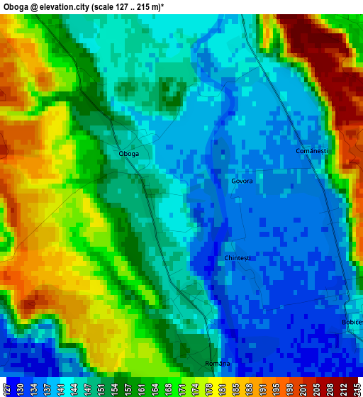
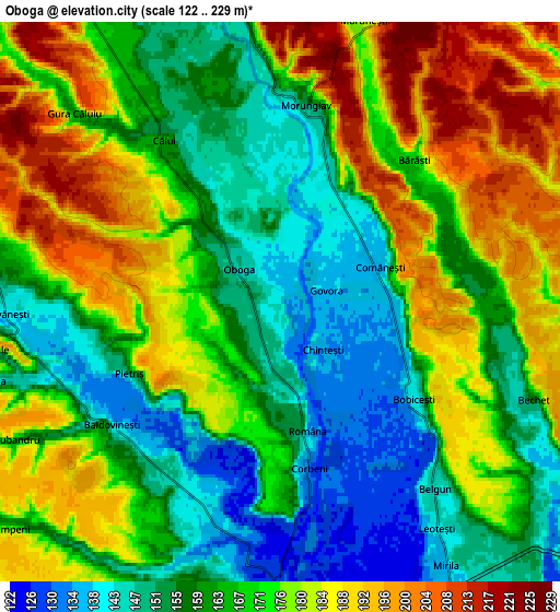
Below is the Elevation map of Oboga, which displays elevation range with different colors. Scale of the first map is from 127 to 215 m (417 to 705 ft) with average elevation of 155.3 meters (=510 ft) [note 1]
These maps also provides idea of topography and contour of this city, they are displayed at different zoom levels. More info about maps, scale and edge coordinates you can find below images.
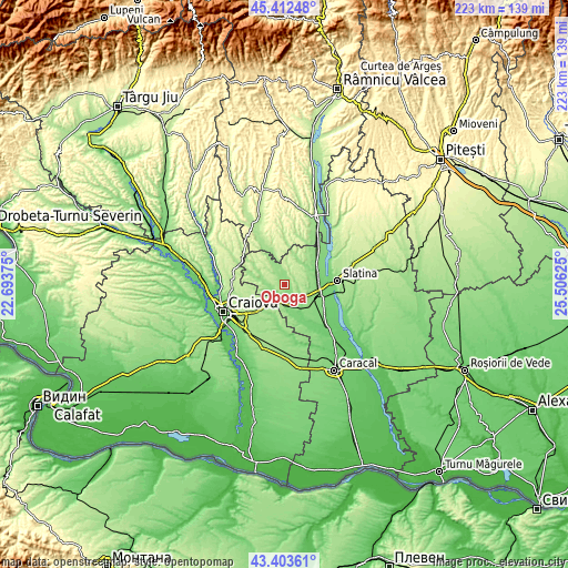
| \ | Map #1 | Map #2 | Topo.Map |
| Scale [m] | 127..215 m | 122..229 m | × |
| Scale [ft] | 417..705 ft | 400..751 ft | × |
| Average | 155.3 m = 510 ft | 168.5 m = 553 ft | × |
| Width | 6.98 km = 4.3 mi | 13.96 km = 8.7 mi | 223.4 km = 138.8 mi |
| Height | 6.98 km = 4.3 mi | 13.96 km = 8.7 mi | 223.4 km = 138.8 mi |
| ↑Max Latitude | 44.44805° | 44.479414° | 45.41248° |
| Latitude at center | 44.41667° | 44.41667° | 44.41667° |
| ↓Min Latitude | 44.385273° | 44.353859° | 43.40361° |
| ← Min Longitude | 24.056055° | 24.012109° | 22.69375° |
| Longitude center | 24.1° | 24.1° | 24.1° |
| →Max Longitude | 24.143945° | 24.187891° | 25.50625° |
Nearby cities:
Cities around Oboga sort by population:
• Balş elevation 133 m
7.4 km,  180°
180°
• Iancu Jianu 160 m
10.7 km,  330°
330°
• Bobiceşti 151 m
5.4 km,  133°
133°
• Baldovineşti 157 m
5.4 km,  226°
226°
• Morunglav 220 m
5.7 km,  13°
13°
• Cârlogani 170 m
11.8 km,  19°
19°
• Cepari 153 m
10.6 km,  32°
32°
• Călui 158 m
5 km,  324°
324°
• Gura Căluiu 166 m
7 km,  312°
312°
• Gropșani 164 m
10.6 km,  284°
284°
• Bârza 119 m
10.4 km,  161°
161°
• Găvănești 141 m
6.6 km,  270°
270°
Multilingual:
 En español:
Oboga elevación 140 m.
 En France:
Oboga élévation 140 m.


Sources and notes:
- [note 1] Map square and city borders are not equal. Map elevation data is calculated only from area inside that square.
- [src 1] Elevation data from geonames database provided with same terms of usage.
- [src 2] The elevation map of Oboga is generated using elevation data from NASA's 3 arcsec (90m) resolution SRTM data.
- [src 3] Base (background) map © OpenStreetMap contributors tiles are generated by Geofabrik and OpenTopoMap.
Copyright & License:
This Oboga Elevation Map is licensed under CC BY-SA. You may reuse any part from this page, if you give a proper credit by linking to this URL:
 More info on terms of use page.