Drăgoteşti elevation
Drăgoteşti (Dolj, Comuna Drăgoteşti), Romania elevation is 122 meters and Drăgoteşti elevation in feet is 400 ft above sea level [src 1]. Drăgoteşti is a seat of a second-order administrative division (feature code) with elevation that is 130 meters (427 ft) smaller than average city elevation in Romania.
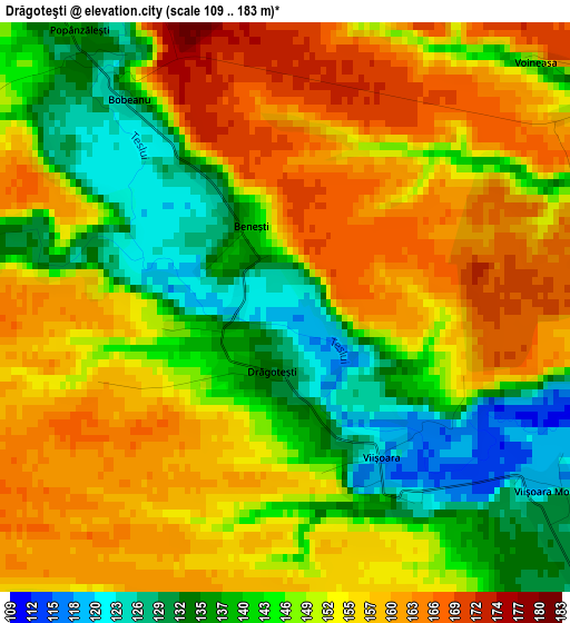
Below is the Elevation map of Drăgoteşti, which displays elevation range with different colors. Scale of the first map is from 109 to 183 m (358 to 600 ft) with average elevation of 149.6 meters (=491 ft) [note 1]
These maps also provides idea of topography and contour of this city, they are displayed at different zoom levels. More info about maps, scale and edge coordinates you can find below images.
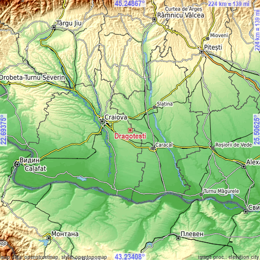
| \ | Map #1 | Topo.Map |
| Scale [m] | 109..183 m | × |
| Scale [ft] | 358..600 ft | × |
| Average | 149.6 m = 491 ft | × |
| Width | 7 km = 4.3 mi | 224 km = 139.2 mi |
| Height | 7 km = 4.3 mi | 224 km = 139.2 mi |
| ↑Max Latitude | 44.28147° | 45.24867° |
| Latitude at center | 44.25° | 44.25° |
| ↓Min Latitude | 44.218513° | 43.23408° |
| ← Min Longitude | 24.056055° | 22.69375° |
| Longitude center | 24.1° | 24.1° |
| →Max Longitude | 24.143945° | 25.50625° |
Nearby cities:
Cities around Drăgoteşti sort by population:
• Balş elevation 133 m
11.1 km,  0°
0°
• Leu 163 m
10.9 km,  227°
227°
• Coşoveni 171 m
13.3 km,  270°
270°
• Dobrun 106 m
9.5 km,  78°
78°
• Voineasa 171 m
4.6 km,  35°
35°
• Braneț 132 m
10.5 km, 36°
• Zănoaga 152 m
10.6 km,  180°
180°
• Osica de Jos 99 m
14.3 km,  92°
92°
• Olari 133 m
10.8 km,  53°
53°
• Bârza 119 m
9.3 km,  20°
20°
• Pârşcoveni 134 m
12 km,  62°
62°
• Teslui 119 m
6.6 km,  138°
138°
Multilingual:
 En español:
Drăgoteşti elevación 122 m.
 En France:
Drăgoteşti élévation 122 m.
 Auf Deutsch:
Drăgoteşti höhe über dem Meeresspiegel ist 122 m.

Sources and notes:
- [note 1] Map square and city borders are not equal. Map elevation data is calculated only from area inside that square.
- [src 1] Elevation data from geonames database provided with same terms of usage.
- [src 2] The elevation map of Drăgoteşti is generated using elevation data from NASA's 3 arcsec (90m) resolution SRTM data.
- [src 3] Base (background) map © OpenStreetMap contributors tiles are generated by Geofabrik and OpenTopoMap.
Copyright & License:
This Drăgoteşti Elevation Map is licensed under CC BY-SA. You may reuse any part from this page, if you give a proper credit by linking to this URL:
 More info on terms of use page.