Bunești elevation
Bunești (Suceava, Comuna Buneşti), Romania elevation is 303 meters and Bunești elevation in feet is 994 ft above sea level [src 1]. Bunești is a seat of a second-order administrative division (feature code) with elevation that is 51 meters (167 ft) bigger than average city elevation in Romania.
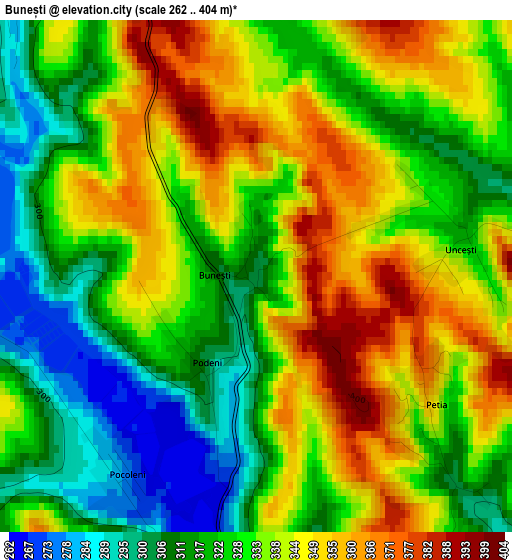
Below is the Elevation map of Bunești, which displays elevation range with different colors. Scale of the first map is from 262 to 404 m (860 to 1325 ft) with average elevation of 331.6 meters (=1088 ft) [note 1]
These maps also provides idea of topography and contour of this city, they are displayed at different zoom levels. More info about maps, scale and edge coordinates you can find below images.
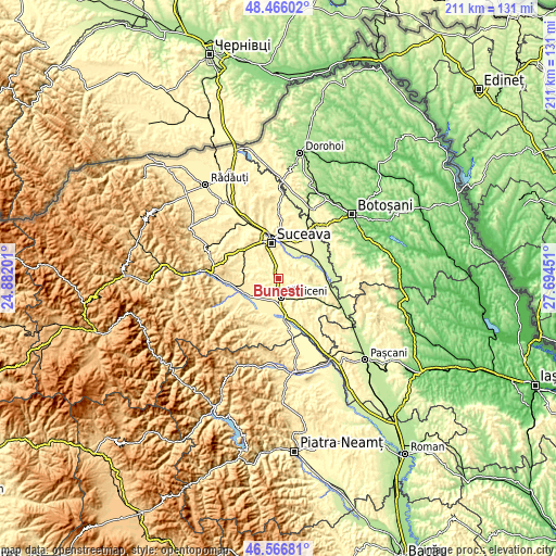
| \ | Map #1 | Topo.Map |
| Scale [m] | 262..404 m | × |
| Scale [ft] | 860..1325 ft | × |
| Average | 331.6 m = 1088 ft | × |
| Width | 6.6 km = 4.1 mi | 211.2 km = 131.2 mi |
| Height | 6.6 km = 4.1 mi | 211.2 km = 131.2 mi |
| ↑Max Latitude | 47.554676° | 48.46602° |
| Latitude at center | 47.52501° | 47.52501° |
| ↓Min Latitude | 47.495327° | 46.56681° |
| ← Min Longitude | 26.244315° | 24.88201° |
| Longitude center | 26.28826° | 26.28826° |
| →Max Longitude | 26.332205° | 27.69451° |
Nearby cities:
Cities around Bunești sort by population:
• Fălticeni elevation 307 m
8.4 km,  173°
173°
• Liteni 314 m
8.1 km,  304°
304°
• Bosanci 360 m
6.8 km,  18°
18°
• Fântânele 375 m
2.3 km,  113°
113°
• Rădăşeni 336 m
7.1 km,  203°
203°
• Moara Carp 305 m
6.2 km,  318°
318°
• Horodniceni 384 m
9.2 km,  275°
275°
• Hârtop 380 m
7.4 km,  121°
121°
• Lămășeni 357 m
5.7 km,  231°
231°
• Moara Nica 351 m
9.8 km,  329°
329°
• Plăvălari 331 m
7.2 km,  47°
47°
• Mihăiești 307 m
5.4 km,  258°
258°
Multilingual:
 En español:
Bunești elevación 303 m.
 En France:
Bunești élévation 303 m.


Sources and notes:
- [note 1] Map square and city borders are not equal. Map elevation data is calculated only from area inside that square.
- [src 1] Elevation data from geonames database provided with same terms of usage.
- [src 2] The elevation map of Bunești is generated using elevation data from NASA's 3 arcsec (90m) resolution SRTM data.
- [src 3] Base (background) map © OpenStreetMap contributors tiles are generated by Geofabrik and OpenTopoMap.
Copyright & License:
This Bunești Elevation Map is licensed under CC BY-SA. You may reuse any part from this page, if you give a proper credit by linking to this URL:
 More info on terms of use page.