Hârtop elevation
Hârtop (Suceava, Comuna Hârtop), Romania elevation is 380 meters and Hârtop elevation in feet is 1247 ft above sea level [src 1]. Hârtop is a seat of a second-order administrative division (feature code) with elevation that is 128 meters (420 ft) bigger than average city elevation in Romania.
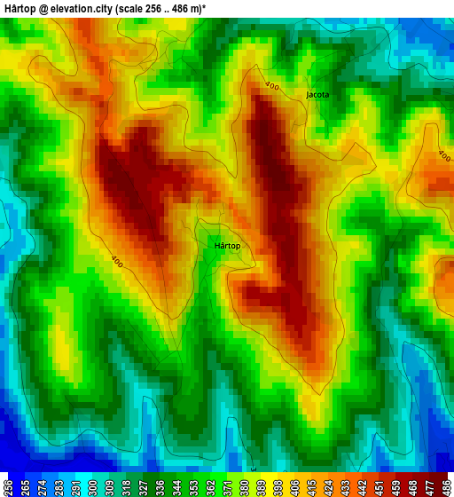
Below is the Elevation map of Hârtop, which displays elevation range with different colors. Scale of the first map is from 256 to 486 m (840 to 1594 ft) with average elevation of 368.5 meters (=1209 ft) [note 1]
These maps also provides idea of topography and contour of this city, they are displayed at different zoom levels. More info about maps, scale and edge coordinates you can find below images.
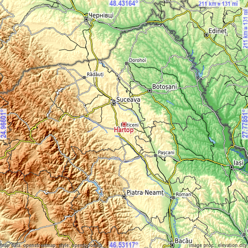
| \ | Map #1 | Topo.Map |
| Scale [m] | 256..486 m | × |
| Scale [ft] | 840..1594 ft | × |
| Average | 368.5 m = 1209 ft | × |
| Width | 6.6 km = 4.1 mi | 211.3 km = 131.3 mi |
| Height | 6.6 km = 4.1 mi | 211.3 km = 131.3 mi |
| ↑Max Latitude | 47.519686° | 48.43164° |
| Latitude at center | 47.49° | 47.49° |
| ↓Min Latitude | 47.460297° | 46.53117° |
| ← Min Longitude | 26.328315° | 24.96601° |
| Longitude center | 26.37226° | 26.37226° |
| →Max Longitude | 26.416205° | 27.77851° |
Nearby cities:
Cities around Hârtop sort by population:
• Fălticeni elevation 307 m
7 km,  230°
230°
• Preuteşti 268 m
5.6 km,  143°
143°
• Udeşti 331 m
9.2 km,  21°
21°
• Fântânele 375 m
5.1 km,  305°
305°
• Rădăşeni 336 m
9.5 km,  254°
254°
• Vultureşti 388 m
6.5 km,  63°
63°
• Basarabi 267 m
6.5 km,  128°
128°
• Arghira 251 m
8.5 km,  117°
117°
• Plăvălari 331 m
8.8 km,  353°
353°
• Dumbrăvița 366 m
10.4 km,  191°
191°
• Fântâna Mare 364 m
10 km,  212°
212°
• Bunești 303 m
7.4 km,  301°
301°
Multilingual:
 En español:
Hârtop elevación 380 m.
 En France:
Hârtop élévation 380 m.


Sources and notes:
- [note 1] Map square and city borders are not equal. Map elevation data is calculated only from area inside that square.
- [src 1] Elevation data from geonames database provided with same terms of usage.
- [src 2] The elevation map of Hârtop is generated using elevation data from NASA's 3 arcsec (90m) resolution SRTM data.
- [src 3] Base (background) map © OpenStreetMap contributors tiles are generated by Geofabrik and OpenTopoMap.
Copyright & License:
This Hârtop Elevation Map is licensed under CC BY-SA. You may reuse any part from this page, if you give a proper credit by linking to this URL:
 More info on terms of use page.