Fălticeni elevation
Fălticeni (Suceava, Municipiul Fãlticeni), Romania elevation is 307 meters and Fălticeni elevation in feet is 1007 ft above sea level [src 1]. Fălticeni is a seat of a second-order administrative division (feature code) with elevation that is 55 meters (180 ft) bigger than average city elevation in Romania.
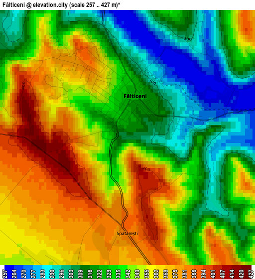
Below is the Elevation map of Fălticeni, which displays elevation range with different colors. Scale of the first map is from 257 to 427 m (843 to 1401 ft) with average elevation of 341.2 meters (=1119 ft) [note 1]
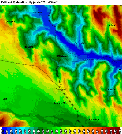
These maps also provides idea of topography and contour of this city, they are displayed at different zoom levels. More info about maps, scale and edge coordinates you can find below images.
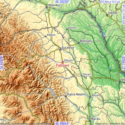
| \ | Map #1 | Map #2 | Topo.Map |
| Scale [m] | 257..427 m | 252..486 m | × |
| Scale [ft] | 843..1401 ft | 827..1594 ft | × |
| Average | 341.2 m = 1119 ft | 352.4 m = 1156 ft | × |
| Width | 6.61 km = 4.1 mi | 13.22 km = 8.2 mi | 211.5 km = 131.4 mi |
| Height | 6.61 km = 4.1 mi | 13.22 km = 8.2 mi | 211.5 km = 131.4 mi |
| ↑Max Latitude | 47.479709° | 47.509401° | 48.39236° |
| Latitude at center | 47.45° | 47.45° | 47.45° |
| ↓Min Latitude | 47.420274° | 47.390532° | 46.49044° |
| ← Min Longitude | 26.256055° | 26.212109° | 24.89375° |
| Longitude center | 26.3° | 26.3° | 26.3° |
| →Max Longitude | 26.343945° | 26.387891° | 27.70625° |
Nearby cities:
Cities around Fălticeni sort by population:
• Preuteşti elevation 268 m
8.8 km,  90°
90°
• Vadu Moldovei 326 m
9 km,  145°
145°
• Baia 360 m
7.3 km,  239°
239°
• Fântânele 375 m
7.5 km,  9°
9°
• Rădăşeni 336 m
4.2 km,  296°
296°
• Bogdăneşti 350 m
9.3 km,  187°
187°
• Hârtop 380 m
7 km,  50°
50°
• Lămășeni 357 m
7.2 km,  311°
311°
• Mihăiești 307 m
9.6 km,  319°
319°
• Dumbrăvița 366 m
6.7 km, 149°
• Fântâna Mare 364 m
4 km,  179°
179°
• Bunești 303 m
8.4 km,  353°
353°
Multilingual:
 En español:
Fălticeni elevación 307 m.
 En France:
Fălticeni élévation 307 m.
 Auf Deutsch:
Fălticeni höhe über dem Meeresspiegel ist 307 m.

Sources and notes:
- [note 1] Map square and city borders are not equal. Map elevation data is calculated only from area inside that square.
- [src 1] Elevation data from geonames database provided with same terms of usage.
- [src 2] The elevation map of Fălticeni is generated using elevation data from NASA's 3 arcsec (90m) resolution SRTM data.
- [src 3] Base (background) map © OpenStreetMap contributors tiles are generated by Geofabrik and OpenTopoMap.
Copyright & License:
This Fălticeni Elevation Map is licensed under CC BY-SA. You may reuse any part from this page, if you give a proper credit by linking to this URL:
 More info on terms of use page.