Plăvălari elevation
Plăvălari (Suceava, Comuna Udeşti), Romania elevation is 331 meters and Plăvălari elevation in feet is 1086 ft above sea level [src 1]. Plăvălari is a populated place (feature code) with elevation that is 79 meters (259 ft) bigger than average city elevation in Romania.
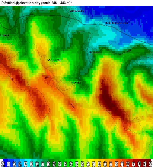
Below is the Elevation map of Plăvălari, which displays elevation range with different colors. Scale of the first map is from 248 to 443 m (814 to 1453 ft) with average elevation of 340.8 meters (=1118 ft) [note 1]
These maps also provides idea of topography and contour of this city, they are displayed at different zoom levels. More info about maps, scale and edge coordinates you can find below images.
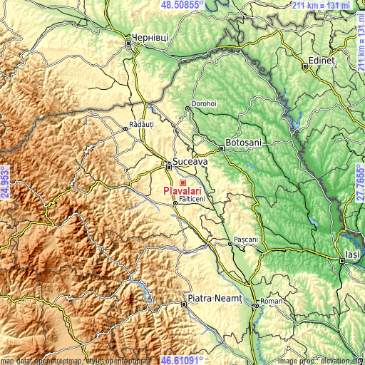
| \ | Map #1 | Topo.Map |
| Scale [m] | 248..443 m | × |
| Scale [ft] | 814..1453 ft | × |
| Average | 340.8 m = 1118 ft | × |
| Width | 6.59 km = 4.1 mi | 211 km = 131.1 mi |
| Height | 6.59 km = 4.1 mi | 211 km = 131.1 mi |
| ↑Max Latitude | 47.597962° | 48.50855° |
| Latitude at center | 47.56832° | 47.56832° |
| ↓Min Latitude | 47.538661° | 46.61091° |
| ← Min Longitude | 26.315305° | 24.953° |
| Longitude center | 26.35925° | 26.35925° |
| →Max Longitude | 26.403195° | 27.7655° |
Nearby cities:
Cities around Plăvălari sort by population:
• Salcea elevation 329 m
9.1 km,  3°
3°
• Udeşti 331 m
4.3 km,  92°
92°
• Vereşti 246 m
6.6 km,  57°
57°
• Bosanci 360 m
3.6 km,  297°
297°
• Fântânele 375 m
6.6 km,  209°
209°
• Ipoteşti 370 m
7.8 km,  313°
313°
• Moara Carp 305 m
9.4 km,  268°
268°
• Vultureşti 388 m
8.9 km,  130°
130°
• Hârtop 380 m
8.8 km,  173°
173°
• Văratec 322 m
8.6 km,  22°
22°
• Prelipca 262 m
4.7 km,  355°
355°
• Bunești 303 m
7.2 km,  227°
227°
Multilingual:
 En español:
Plăvălari elevación 331 m.
 En France:
Plăvălari élévation 331 m.
 Auf Deutsch:
Plăvălari höhe über dem Meeresspiegel ist 331 m.

Sources and notes:
- [note 1] Map square and city borders are not equal. Map elevation data is calculated only from area inside that square.
- [src 1] Elevation data from geonames database provided with same terms of usage.
- [src 2] The elevation map of Plăvălari is generated using elevation data from NASA's 3 arcsec (90m) resolution SRTM data.
- [src 3] Base (background) map © OpenStreetMap contributors tiles are generated by Geofabrik and OpenTopoMap.
Copyright & License:
This Plăvălari Elevation Map is licensed under CC BY-SA. You may reuse any part from this page, if you give a proper credit by linking to this URL:
 More info on terms of use page.