Văratec elevation
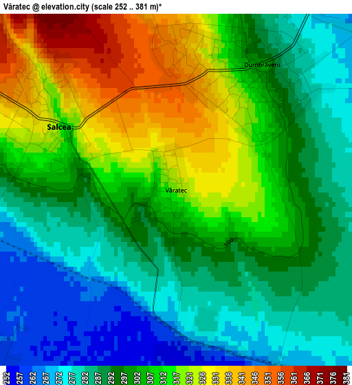
Văratec (Suceava, Oraş Salcea), Romania elevation is 322 meters and Văratec elevation in feet is 1056 ft above sea level [src 1]. Văratec is a populated place (feature code) with elevation that is 70 meters (230 ft) bigger than average city elevation in Romania.
Below is the Elevation map of Văratec, which displays elevation range with different colors. Scale of the first map is from 252 to 381 m (827 to 1250 ft) with average elevation of 300.8 meters (=987 ft) [note 1]
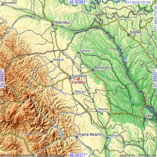
These maps also provides idea of topography and contour of this city, they are displayed at different zoom levels. More info about maps, scale and edge coordinates you can find below images.
| \ | Map #1 | Topo.Map |
| Scale [m] | 252..381 m | × |
| Scale [ft] | 827..1250 ft | × |
| Average | 300.8 m = 987 ft | × |
| Width | 6.58 km = 4.1 mi | 210.7 km = 130.9 mi |
| Height | 6.58 km = 4.1 mi | 210.7 km = 130.9 mi |
| ↑Max Latitude | 47.669481° | 48.57881° |
| Latitude at center | 47.63988° | 47.63988° |
| ↓Min Latitude | 47.610262° | 46.68377° |
| ← Min Longitude | 26.359175° | 24.99687° |
| Longitude center | 26.40312° | 26.40312° |
| →Max Longitude | 26.447065° | 27.80937° |
Nearby cities:
Cities around Văratec sort by population:
• Salcea elevation 329 m
3 km,  292°
292°
• Dumbrăveni 328 m
1.5 km,  42°
42°
• Udeşti 331 m
8.2 km,  172°
172°
• Vereşti 246 m
5 km,  152°
152°
• Bosanci 360 m
9 km,  225°
225°
• Siminicea 296 m
6.7 km,  357°
357°
• Plopeni 328 m
5.2 km, 293°
• Corocăiești 265 m
6.1 km,  96°
96°
• Stamate 247 m
9.3 km,  113°
113°
• Bursuceni 264 m
5.5 km,  77°
77°
• Prelipca 262 m
4.9 km, 228°
• Plăvălari 331 m
8.6 km,  202°
202°
Multilingual:
 En español:
Văratec elevación 322 m.
 En France:
Văratec élévation 322 m.


Sources and notes:
- [note 1] Map square and city borders are not equal. Map elevation data is calculated only from area inside that square.
- [src 1] Elevation data from geonames database provided with same terms of usage.
- [src 2] The elevation map of Văratec is generated using elevation data from NASA's 3 arcsec (90m) resolution SRTM data.
- [src 3] Base (background) map © OpenStreetMap contributors tiles are generated by Geofabrik and OpenTopoMap.
Copyright & License:
This Văratec Elevation Map is licensed under CC BY-SA. You may reuse any part from this page, if you give a proper credit by linking to this URL:
 More info on terms of use page.