Arghira elevation
Arghira (Suceava, Comuna Preuteşti), Romania elevation is 251 meters and Arghira elevation in feet is 823 ft above sea level [src 1]. Arghira is a populated place (feature code) with elevation that is 1 meters (3 ft) smaller than average city elevation in Romania.
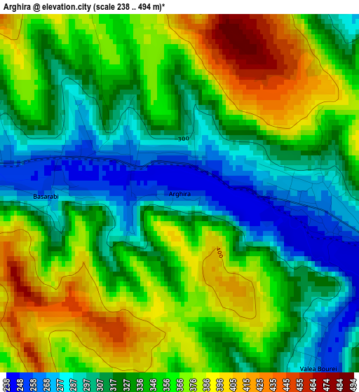
Below is the Elevation map of Arghira, which displays elevation range with different colors. Scale of the first map is from 238 to 494 m (781 to 1621 ft) with average elevation of 341.1 meters (=1119 ft) [note 1]
These maps also provides idea of topography and contour of this city, they are displayed at different zoom levels. More info about maps, scale and edge coordinates you can find below images.
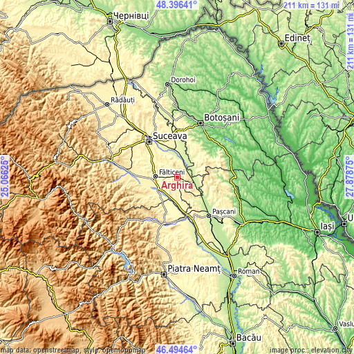
| \ | Map #1 | Topo.Map |
| Scale [m] | 238..494 m | × |
| Scale [ft] | 781..1621 ft | × |
| Average | 341.1 m = 1119 ft | × |
| Width | 6.61 km = 4.1 mi | 211.5 km = 131.4 mi |
| Height | 6.61 km = 4.1 mi | 211.4 km = 131.4 mi |
| ↑Max Latitude | 47.483827° | 48.39641° |
| Latitude at center | 47.45412° | 47.45412° |
| ↓Min Latitude | 47.424397° | 46.49464° |
| ← Min Longitude | 26.428555° | 25.06625° |
| Longitude center | 26.4725° | 26.4725° |
| →Max Longitude | 26.516445° | 27.87875° |
Nearby cities:
Cities around Arghira sort by population:
• Dolhasca elevation 231 m
9.9 km,  103°
103°
• Preuteşti 268 m
4.2 km,  263°
263°
• Vadu Moldovei 326 m
11.2 km,  225°
225°
• Liteni 247 m
8.5 km,  29°
29°
• Vultureşti 388 m
7.2 km,  346°
346°
• Rotunda 273 m
5.4 km,  46°
46°
• Hârtop 380 m
8.5 km,  297°
297°
• Dolheștii-Mari 272 m
3.1 km, 98°
• Gulia 243 m
11.3 km,  114°
114°
• Basarabi 267 m
2.5 km,  268°
268°
• Dolheștii Mici 259 m
6.3 km, 108°
• Roșcani 232 m
10.5 km, 33°
Multilingual:
 En español:
Arghira elevación 251 m.
 En France:
Arghira élévation 251 m.


Sources and notes:
- [note 1] Map square and city borders are not equal. Map elevation data is calculated only from area inside that square.
- [src 1] Elevation data from geonames database provided with same terms of usage.
- [src 2] The elevation map of Arghira is generated using elevation data from NASA's 3 arcsec (90m) resolution SRTM data.
- [src 3] Base (background) map © OpenStreetMap contributors tiles are generated by Geofabrik and OpenTopoMap.
Copyright & License:
This Arghira Elevation Map is licensed under CC BY-SA. You may reuse any part from this page, if you give a proper credit by linking to this URL:
 More info on terms of use page.