Liteni elevation
Liteni (Suceava, Comuna Moara), Romania elevation is 314 meters and Liteni elevation in feet is 1030 ft above sea level [src 1]. Liteni is a populated place (feature code) with elevation that is 62 meters (203 ft) bigger than average city elevation in Romania.
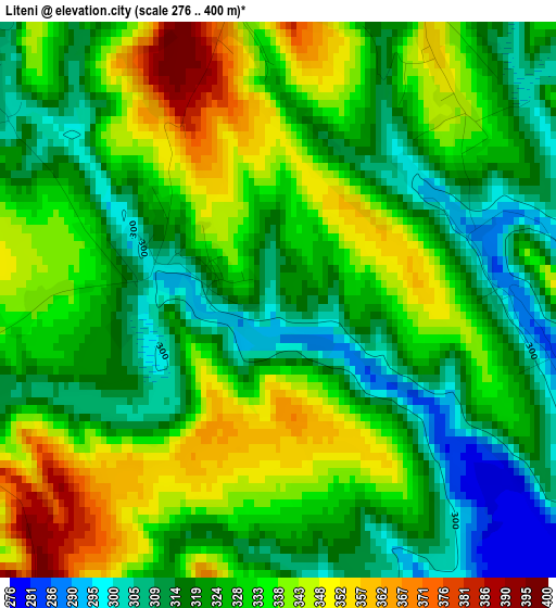
Below is the Elevation map of Liteni, which displays elevation range with different colors. Scale of the first map is from 276 to 400 m (906 to 1312 ft) with average elevation of 328.5 meters (=1078 ft) [note 1]
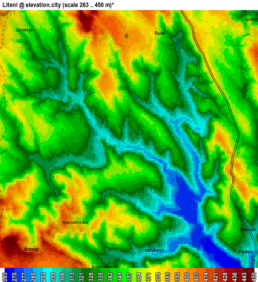
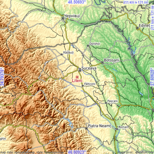
These maps also provides idea of topography and contour of this city, they are displayed at different zoom levels. More info about maps, scale and edge coordinates you can find below images.
| \ | Map #1 | Map #2 | Topo.Map |
| Scale [m] | 276..400 m | 263..450 m | × |
| Scale [ft] | 906..1312 ft | 863..1476 ft | × |
| Average | 328.5 m = 1078 ft | 345.6 m = 1134 ft | × |
| Width | 6.59 km = 4.1 mi | 13.19 km = 8.2 mi | 211 km = 131.1 mi |
| Height | 6.59 km = 4.1 mi | 13.19 km = 8.2 mi | 211 km = 131.1 mi |
| ↑Max Latitude | 47.596313° | 47.625939° | 48.50693° |
| Latitude at center | 47.56667° | 47.56667° | 47.56667° |
| ↓Min Latitude | 47.53701° | 47.507334° | 46.60923° |
| ← Min Longitude | 26.156055° | 26.112109° | 24.79375° |
| Longitude center | 26.2° | 26.2° | 26.2° |
| →Max Longitude | 26.243945° | 26.287891° | 27.60625° |
Nearby cities:
Cities around Liteni sort by population:
• Suceava elevation 360 m
8.3 km,  26°
26°
• Scheia 307 m
9.6 km,  15°
15°
• Bosanci 360 m
8.9 km,  78°
78°
• Ipoteşti 370 m
8.4 km,  48°
48°
• Moara Carp 305 m
2.5 km,  90°
90°
• Horodniceni 384 m
4.5 km,  214°
214°
• Stroiești 353 m
7.5 km,  318°
318°
• Drăgoiești 397 m
8.9 km,  258°
258°
• Lămășeni 357 m
8.4 km,  165°
165°
• Moara Nica 351 m
4.2 km, 24°
• Mihăiești 307 m
5.8 km, 167°
• Bunești 303 m
8.1 km,  124°
124°
Multilingual:
 En español:
Liteni elevación 314 m.
 En France:
Liteni élévation 314 m.


Sources and notes:
- [note 1] Map square and city borders are not equal. Map elevation data is calculated only from area inside that square.
- [src 1] Elevation data from geonames database provided with same terms of usage.
- [src 2] The elevation map of Liteni is generated using elevation data from NASA's 3 arcsec (90m) resolution SRTM data.
- [src 3] Base (background) map © OpenStreetMap contributors tiles are generated by Geofabrik and OpenTopoMap.
Copyright & License:
This Liteni Elevation Map is licensed under CC BY-SA. You may reuse any part from this page, if you give a proper credit by linking to this URL:
 More info on terms of use page.