Scheia elevation
Scheia (Suceava, Comuna Scheia), Romania elevation is 307 meters and Scheia elevation in feet is 1007 ft above sea level [src 1]. Scheia is a seat of a second-order administrative division (feature code) with elevation that is 55 meters (180 ft) bigger than average city elevation in Romania.
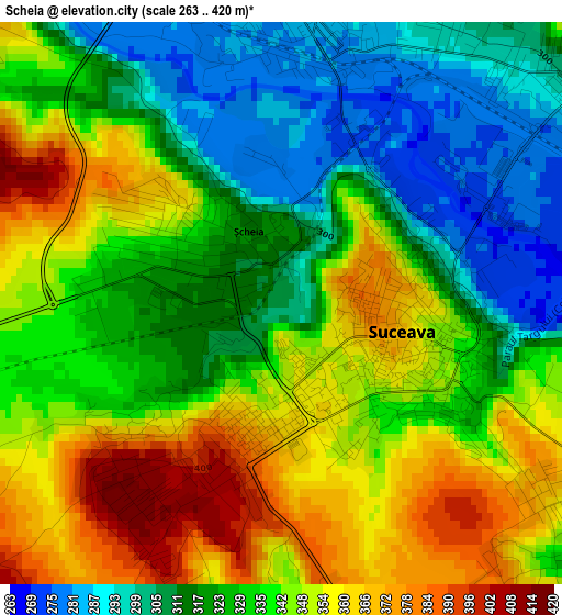
Below is the Elevation map of Scheia, which displays elevation range with different colors. Scale of the first map is from 263 to 420 m (863 to 1378 ft) with average elevation of 334.6 meters (=1098 ft) [note 1]
These maps also provides idea of topography and contour of this city, they are displayed at different zoom levels. More info about maps, scale and edge coordinates you can find below images.
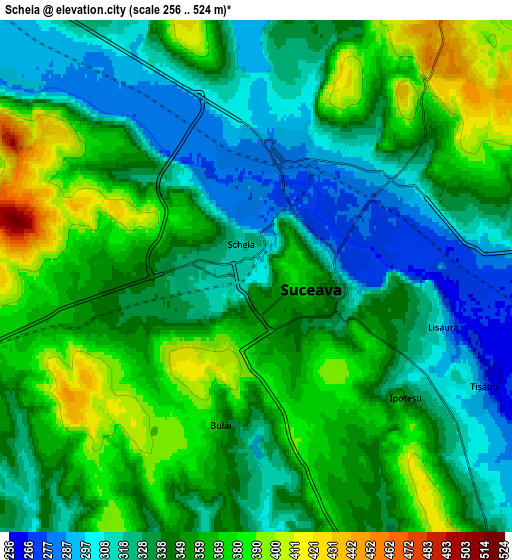
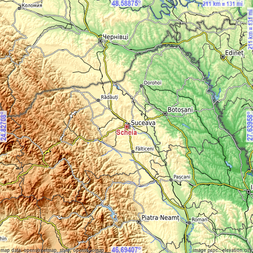
| \ | Map #1 | Map #2 | Topo.Map |
| Scale [m] | 263..420 m | 256..524 m | × |
| Scale [ft] | 863..1378 ft | 840..1719 ft | × |
| Average | 334.6 m = 1098 ft | 345.8 m = 1135 ft | × |
| Width | 6.58 km = 4.1 mi | 13.17 km = 8.2 mi | 210.7 km = 130.9 mi |
| Height | 6.58 km = 4.1 mi | 13.17 km = 8.2 mi | 210.7 km = 130.9 mi |
| ↑Max Latitude | 47.679596° | 47.709175° | 48.58875° |
| Latitude at center | 47.65° | 47.65° | 47.65° |
| ↓Min Latitude | 47.620388° | 47.590758° | 46.69407° |
| ← Min Longitude | 26.189385° | 26.145439° | 24.82708° |
| Longitude center | 26.23333° | 26.23333° | 26.23333° |
| →Max Longitude | 26.277275° | 26.321221° | 27.63958° |
Nearby cities:
Cities around Scheia sort by population:
• Suceava elevation 360 m
2.2 km,  146°
146°
• Liteni 314 m
9.6 km,  195°
195°
• Bosanci 360 m
9.7 km,  139°
139°
• Ipoteşti 370 m
5.3 km,  134°
134°
• Moara Carp 305 m
9.3 km,  180°
180°
• Pătrăuţi 413 m
7.8 km,  341°
341°
• Mitocu Dragomirnei 380 m
9.3 km,  7°
7°
• Plopeni 328 m
8 km,  83°
83°
• Stroiești 353 m
8.4 km,  243°
243°
• Mihoveni 374 m
5.1 km,  311°
311°
• Costâna 302 m
9.8 km,  298°
298°
• Moara Nica 351 m
5.5 km,  188°
188°
Multilingual:
 En español:
Scheia elevación 307 m.
 En France:
Scheia élévation 307 m.


Sources and notes:
- [note 1] Map square and city borders are not equal. Map elevation data is calculated only from area inside that square.
- [src 1] Elevation data from geonames database provided with same terms of usage.
- [src 2] The elevation map of Scheia is generated using elevation data from NASA's 3 arcsec (90m) resolution SRTM data.
- [src 3] Base (background) map © OpenStreetMap contributors tiles are generated by Geofabrik and OpenTopoMap.
Copyright & License:
This Scheia Elevation Map is licensed under CC BY-SA. You may reuse any part from this page, if you give a proper credit by linking to this URL:
 More info on terms of use page.