Mihoveni elevation
Mihoveni (Suceava, Comuna Scheia), Romania elevation is 374 meters and Mihoveni elevation in feet is 1227 ft above sea level [src 1]. Mihoveni is a populated place (feature code) with elevation that is 122 meters (400 ft) bigger than average city elevation in Romania.
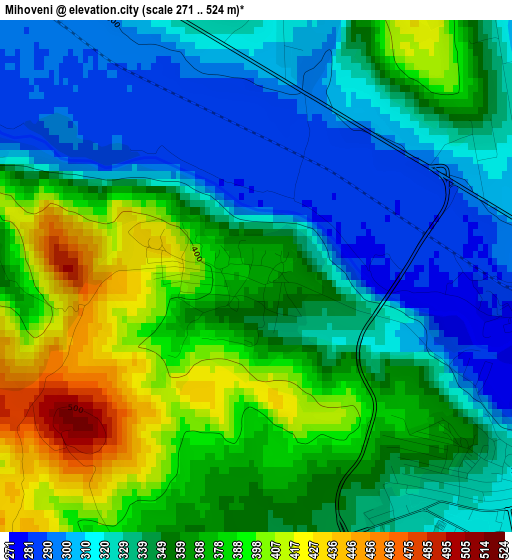
Below is the Elevation map of Mihoveni, which displays elevation range with different colors. Scale of the first map is from 271 to 524 m (889 to 1719 ft) with average elevation of 351.3 meters (=1153 ft) [note 1]
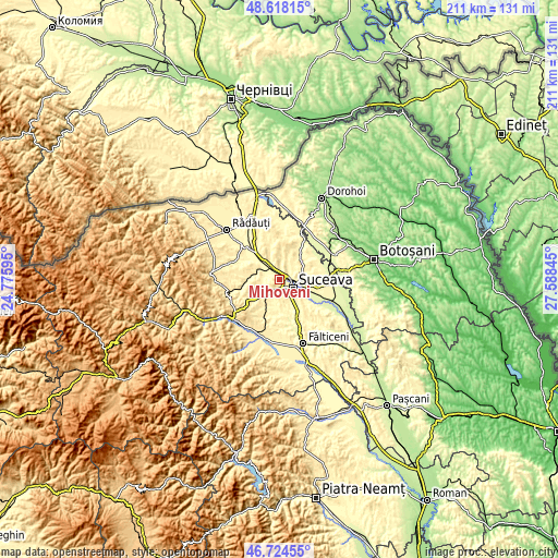
These maps also provides idea of topography and contour of this city, they are displayed at different zoom levels. More info about maps, scale and edge coordinates you can find below images.
| \ | Map #1 | Topo.Map |
| Scale [m] | 271..524 m | × |
| Scale [ft] | 889..1719 ft | × |
| Average | 351.3 m = 1153 ft | × |
| Width | 6.58 km = 4.1 mi | 210.5 km = 130.8 mi |
| Height | 6.58 km = 4.1 mi | 210.5 km = 130.8 mi |
| ↑Max Latitude | 47.709519° | 48.61815° |
| Latitude at center | 47.67994° | 47.67994° |
| ↓Min Latitude | 47.650344° | 46.72455° |
| ← Min Longitude | 26.138255° | 24.77595° |
| Longitude center | 26.1822° | 26.1822° |
| →Max Longitude | 26.226145° | 27.58845° |
Nearby cities:
Cities around Mihoveni sort by population:
• Suceava elevation 360 m
7.3 km,  135°
135°
• Adâncata 401 m
10.6 km,  56°
56°
• Scheia 307 m
5.1 km,  131°
131°
• Dărmăneşti 340 m
6.4 km,  337°
337°
• Ipoteşti 370 m
10.3 km, 132°
• Pătrăuţi 413 m
4.3 km,  18°
18°
• Mitocu Dragomirnei 380 m
7.8 km,  40°
40°
• Stroiești 353 m
7.9 km,  207°
207°
• Măriței 402 m
8.5 km, 341°
• Costâna 302 m
4.9 km,  286°
286°
• Moara Nica 351 m
9.3 km,  160°
160°
• Părhăuți 303 m
7.7 km,  296°
296°
Multilingual:
 En español:
Mihoveni elevación 374 m.
 En France:
Mihoveni élévation 374 m.
 Auf Deutsch:
Mihoveni höhe über dem Meeresspiegel ist 374 m.

Sources and notes:
- [note 1] Map square and city borders are not equal. Map elevation data is calculated only from area inside that square.
- [src 1] Elevation data from geonames database provided with same terms of usage.
- [src 2] The elevation map of Mihoveni is generated using elevation data from NASA's 3 arcsec (90m) resolution SRTM data.
- [src 3] Base (background) map © OpenStreetMap contributors tiles are generated by Geofabrik and OpenTopoMap.
Copyright & License:
This Mihoveni Elevation Map is licensed under CC BY-SA. You may reuse any part from this page, if you give a proper credit by linking to this URL:
 More info on terms of use page.