Părhăuți elevation
Părhăuți (Suceava, Comuna Todireşti), Romania elevation is 303 meters and Părhăuți elevation in feet is 994 ft above sea level [src 1]. Părhăuți is a populated place (feature code) with elevation that is 51 meters (167 ft) bigger than average city elevation in Romania.
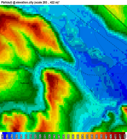
Below is the Elevation map of Părhăuți, which displays elevation range with different colors. Scale of the first map is from 283 to 422 m (928 to 1385 ft) with average elevation of 331.3 meters (=1087 ft) [note 1]
These maps also provides idea of topography and contour of this city, they are displayed at different zoom levels. More info about maps, scale and edge coordinates you can find below images.
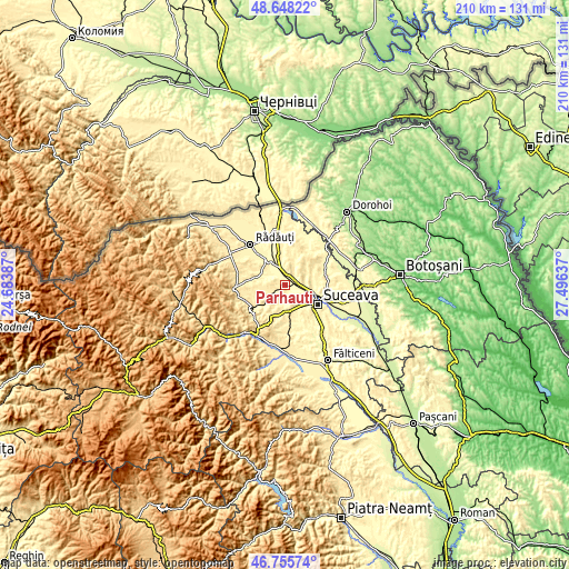
| \ | Map #1 | Topo.Map |
| Scale [m] | 283..422 m | × |
| Scale [ft] | 928..1385 ft | × |
| Average | 331.3 m = 1087 ft | × |
| Width | 6.58 km = 4.1 mi | 210.4 km = 130.7 mi |
| Height | 6.58 km = 4.1 mi | 210.4 km = 130.7 mi |
| ↑Max Latitude | 47.740131° | 48.64822° |
| Latitude at center | 47.71057° | 47.71057° |
| ↓Min Latitude | 47.680992° | 46.75574° |
| ← Min Longitude | 26.046175° | 24.68387° |
| Longitude center | 26.09012° | 26.09012° |
| →Max Longitude | 26.134065° | 27.49637° |
Nearby cities:
Cities around Părhăuți sort by population:
• Cajvana elevation 389 m
9.3 km,  262°
262°
• Dărmăneşti 340 m
5.1 km,  60°
60°
• Todireşti 365 m
4.4 km,  254°
254°
• Pătrăuţi 413 m
8.2 km,  85°
85°
• Iaslovăț 361 m
10 km,  302°
302°
• Mihoveni 374 m
7.7 km,  116°
116°
• Bălăceana 359 m
8.1 km,  203°
203°
• Măriței 402 m
6.3 km,  41°
41°
• Soloneț 346 m
5.1 km,  238°
238°
• Costâna 302 m
2.9 km,  132°
132°
• Comănești 364 m
8.9 km, 238°
• Humoreni 356 m
9.4 km, 238°
Multilingual:
 En español:
Părhăuți elevación 303 m.
 En France:
Părhăuți élévation 303 m.
 Auf Deutsch:
Părhăuți höhe über dem Meeresspiegel ist 303 m.

Sources and notes:
- [note 1] Map square and city borders are not equal. Map elevation data is calculated only from area inside that square.
- [src 1] Elevation data from geonames database provided with same terms of usage.
- [src 2] The elevation map of Părhăuți is generated using elevation data from NASA's 3 arcsec (90m) resolution SRTM data.
- [src 3] Base (background) map © OpenStreetMap contributors tiles are generated by Geofabrik and OpenTopoMap.
Copyright & License:
This Părhăuți Elevation Map is licensed under CC BY-SA. You may reuse any part from this page, if you give a proper credit by linking to this URL:
 More info on terms of use page.