Negri elevation
Negri (Bacău, Comuna Negri), Romania elevation is 162 meters and Negri elevation in feet is 531 ft above sea level [src 1]. Negri is a seat of a second-order administrative division (feature code) with elevation that is 90 meters (295 ft) smaller than average city elevation in Romania.
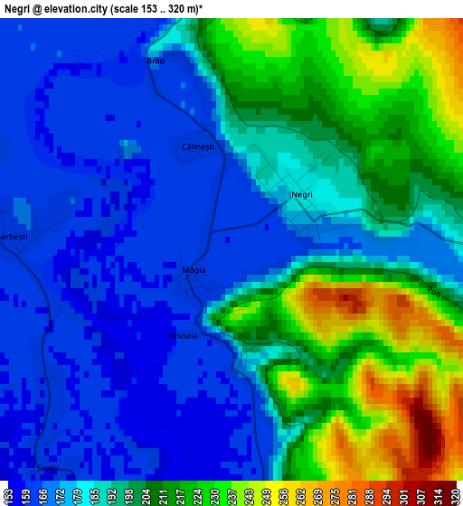
Below is the Elevation map of Negri, which displays elevation range with different colors. Scale of the first map is from 153 to 320 m (502 to 1050 ft) with average elevation of 191.9 meters (=630 ft) [note 1]
These maps also provides idea of topography and contour of this city, they are displayed at different zoom levels. More info about maps, scale and edge coordinates you can find below images.
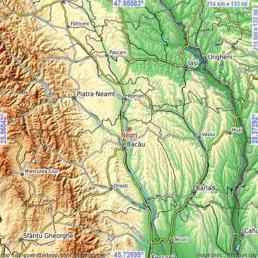
| \ | Map #1 | Topo.Map |
| Scale [m] | 153..320 m | × |
| Scale [ft] | 502..1050 ft | × |
| Average | 191.9 m = 630 ft | × |
| Width | 6.7 km = 4.2 mi | 214.5 km = 133.3 mi |
| Height | 6.7 km = 4.2 mi | 214.5 km = 133.3 mi |
| ↑Max Latitude | 46.73013° | 47.65583° |
| Latitude at center | 46.7° | 46.7° |
| ↓Min Latitude | 46.669853° | 45.72695° |
| ← Min Longitude | 26.922725° | 25.56042° |
| Longitude center | 26.96667° | 26.96667° |
| →Max Longitude | 27.010615° | 28.37292° |
Nearby cities:
Cities around Negri sort by population:
• Filipeşti elevation 173 m
8.4 km,  311°
311°
• Traian 205 m
9 km,  145°
145°
• Icuseşti 169 m
11.4 km,  347°
347°
• Bereşti-Bistriţa 254 m
10.3 km,  280°
280°
• Prăjești 181 m
5.1 km,  171°
171°
• Roşiori 232 m
9.1 km,  78°
78°
• Dămieneşti 178 m
3.9 km,  18°
18°
• Lilieci 176 m
10.7 km,  222°
222°
• Poiana 197 m
3.9 km,  92°
92°
• Săucești 159 m
9.3 km,  192°
192°
• Cârligi 208 m
11.5 km, 309°
• Iteşti 241 m
8.9 km,  234°
234°
Multilingual:
 En español:
Negri elevación 162 m.
 En France:
Negri élévation 162 m.


Sources and notes:
- [note 1] Map square and city borders are not equal. Map elevation data is calculated only from area inside that square.
- [src 1] Elevation data from geonames database provided with same terms of usage.
- [src 2] The elevation map of Negri is generated using elevation data from NASA's 3 arcsec (90m) resolution SRTM data.
- [src 3] Base (background) map © OpenStreetMap contributors tiles are generated by Geofabrik and OpenTopoMap.
Copyright & License:
This Negri Elevation Map is licensed under CC BY-SA. You may reuse any part from this page, if you give a proper credit by linking to this URL:
 More info on terms of use page.