Iteşti elevation
Iteşti (Bacău, Comuna Iteşti), Romania elevation is 241 meters and Iteşti elevation in feet is 791 ft above sea level [src 1]. Iteşti is a seat of a second-order administrative division (feature code) with elevation that is 11 meters (36 ft) smaller than average city elevation in Romania.
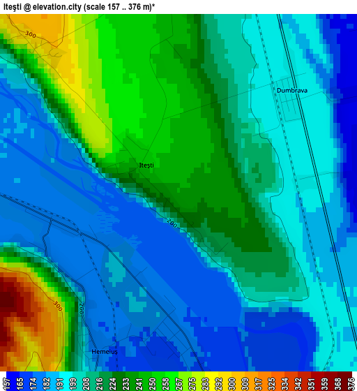
Below is the Elevation map of Iteşti, which displays elevation range with different colors. Scale of the first map is from 157 to 376 m (515 to 1234 ft) with average elevation of 211.9 meters (=695 ft) [note 1]
These maps also provides idea of topography and contour of this city, they are displayed at different zoom levels. More info about maps, scale and edge coordinates you can find below images.
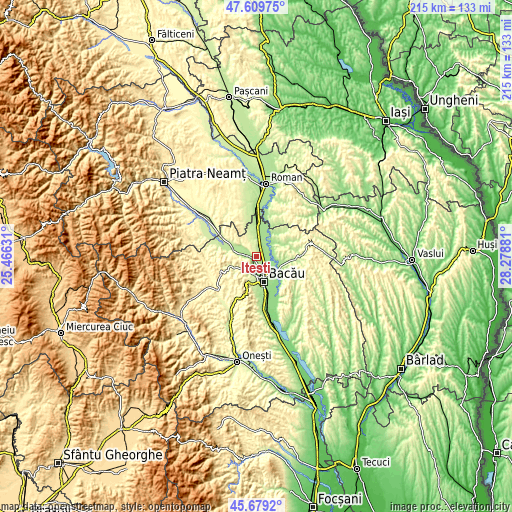
| \ | Map #1 | Topo.Map |
| Scale [m] | 157..376 m | × |
| Scale [ft] | 515..1234 ft | × |
| Average | 211.9 m = 695 ft | × |
| Width | 6.71 km = 4.2 mi | 214.7 km = 133.4 mi |
| Height | 6.71 km = 4.2 mi | 214.6 km = 133.3 mi |
| ↑Max Latitude | 46.683246° | 47.60975° |
| Latitude at center | 46.65309° | 46.65309° |
| ↓Min Latitude | 46.622917° | 45.6792° |
| ← Min Longitude | 26.828615° | 25.46631° |
| Longitude center | 26.87256° | 26.87256° |
| →Max Longitude | 26.916505° | 28.27881° |
Nearby cities:
Cities around Iteşti sort by population:
• Mărgineni-Munteni elevation 164 m
6.3 km,  160°
160°
• Bereşti-Bistriţa 254 m
7.7 km,  337°
337°
• Negri 162 m
8.9 km,  54°
54°
• Mărgineni 198 m
7.5 km,  192°
192°
• Prăjești 181 m
7.9 km,  88°
88°
• Lespezi 193 m
8 km,  279°
279°
• Gârleni 187 m
5.7 km,  285°
285°
• Lilieci 176 m
2.7 km,  181°
181°
• Gârlenii de Sus 188 m
5.9 km,  271°
271°
• Barați 181 m
8.6 km, 180°
• Săucești 159 m
6.5 km,  126°
126°
• Hemeiuș 175 m
3.3 km,  205°
205°
Multilingual:
 En español:
Iteşti elevación 241 m.
 En France:
Iteşti élévation 241 m.


Sources and notes:
- [note 1] Map square and city borders are not equal. Map elevation data is calculated only from area inside that square.
- [src 1] Elevation data from geonames database provided with same terms of usage.
- [src 2] The elevation map of Iteşti is generated using elevation data from NASA's 3 arcsec (90m) resolution SRTM data.
- [src 3] Base (background) map © OpenStreetMap contributors tiles are generated by Geofabrik and OpenTopoMap.
Copyright & License:
This Iteşti Elevation Map is licensed under CC BY-SA. You may reuse any part from this page, if you give a proper credit by linking to this URL:
 More info on terms of use page.