Prăjești elevation
Prăjești (Bacău, Comuna Prăjeşti), Romania elevation is 181 meters and Prăjești elevation in feet is 594 ft above sea level [src 1]. Prăjești is a seat of a second-order administrative division (feature code) with elevation that is 71 meters (233 ft) smaller than average city elevation in Romania.
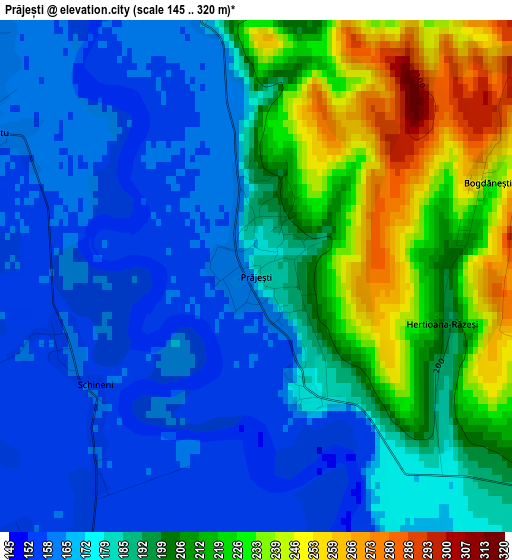
Below is the Elevation map of Prăjești, which displays elevation range with different colors. Scale of the first map is from 145 to 320 m (476 to 1050 ft) with average elevation of 190.1 meters (=624 ft) [note 1]
These maps also provides idea of topography and contour of this city, they are displayed at different zoom levels. More info about maps, scale and edge coordinates you can find below images.
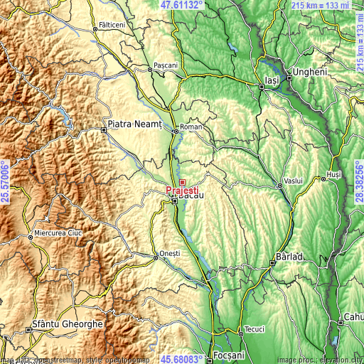
| \ | Map #1 | Topo.Map |
| Scale [m] | 145..320 m | × |
| Scale [ft] | 476..1050 ft | × |
| Average | 190.1 m = 624 ft | × |
| Width | 6.71 km = 4.2 mi | 214.7 km = 133.4 mi |
| Height | 6.71 km = 4.2 mi | 214.6 km = 133.3 mi |
| ↑Max Latitude | 46.684845° | 47.61132° |
| Latitude at center | 46.65469° | 46.65469° |
| ↓Min Latitude | 46.624518° | 45.68083° |
| ← Min Longitude | 26.932365° | 25.57006° |
| Longitude center | 26.97631° | 26.97631° |
| →Max Longitude | 27.020255° | 28.38256° |
Nearby cities:
Cities around Prăjești sort by population:
• Mărgineni-Munteni elevation 164 m
8.4 km,  223°
223°
• Traian 205 m
5 km,  118°
118°
• Secuieni 297 m
9.5 km,  93°
93°
• Negri 162 m
5.1 km,  351°
351°
• Bijghir 180 m
6.7 km,  151°
151°
• Dămieneşti 178 m
8.8 km,  3°
3°
• Lilieci 176 m
8.5 km,  250°
250°
• Poiana 197 m
5.8 km,  33°
33°
• Săucești 159 m
4.8 km,  213°
213°
• Hemeiuș 175 m
9.8 km, 251°
• Holt 155 m
8.5 km,  180°
180°
• Iteşti 241 m
7.9 km,  268°
268°
Multilingual:
 En español:
Prăjești elevación 181 m.
 En France:
Prăjești élévation 181 m.
 Auf Deutsch:
Prăjești höhe über dem Meeresspiegel ist 181 m.

Sources and notes:
- [note 1] Map square and city borders are not equal. Map elevation data is calculated only from area inside that square.
- [src 1] Elevation data from geonames database provided with same terms of usage.
- [src 2] The elevation map of Prăjești is generated using elevation data from NASA's 3 arcsec (90m) resolution SRTM data.
- [src 3] Base (background) map © OpenStreetMap contributors tiles are generated by Geofabrik and OpenTopoMap.
Copyright & License:
This Prăjești Elevation Map is licensed under CC BY-SA. You may reuse any part from this page, if you give a proper credit by linking to this URL:
 More info on terms of use page.