Cârligi elevation
Cârligi (Bacău, Comuna Filipeşti), Romania elevation is 208 meters and Cârligi elevation in feet is 682 ft above sea level [src 1]. Cârligi is a populated place (feature code) with elevation that is 44 meters (144 ft) smaller than average city elevation in Romania.
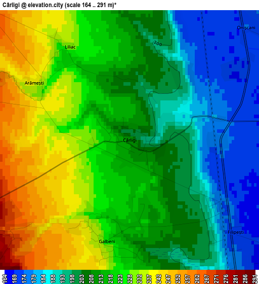
Below is the Elevation map of Cârligi, which displays elevation range with different colors. Scale of the first map is from 164 to 291 m (538 to 955 ft) with average elevation of 213.1 meters (=699 ft) [note 1]
These maps also provides idea of topography and contour of this city, they are displayed at different zoom levels. More info about maps, scale and edge coordinates you can find below images.
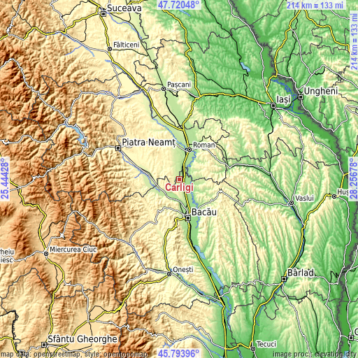
| \ | Map #1 | Topo.Map |
| Scale [m] | 164..291 m | × |
| Scale [ft] | 538..955 ft | × |
| Average | 213.1 m = 699 ft | × |
| Width | 6.69 km = 4.2 mi | 214.2 km = 133.1 mi |
| Height | 6.69 km = 4.2 mi | 214.2 km = 133.1 mi |
| ↑Max Latitude | 46.795923° | 47.72048° |
| Latitude at center | 46.76583° | 46.76583° |
| ↓Min Latitude | 46.73572° | 45.79396° |
| ← Min Longitude | 26.806585° | 25.44428° |
| Longitude center | 26.85053° | 26.85053° |
| →Max Longitude | 26.894475° | 28.25678° |
Nearby cities:
Cities around Cârligi sort by population:
• Filipeşti elevation 173 m
3.1 km,  125°
125°
• Icuseşti 169 m
7.4 km,  58°
58°
• Bahna 282 m
5.5 km,  290°
290°
• Racova 238 m
10.6 km,  226°
226°
• Bereşti-Bistriţa 254 m
5.6 km,  193°
193°
• Negri 162 m
11.5 km, 129°
• Moldoveni 283 m
9.9 km,  319°
319°
• Dămieneşti 178 m
10.7 km,  109°
109°
• Gârleni 187 m
11.7 km,  199°
199°
• Izvoare 278 m
4.2 km,  240°
240°
• Hociungi 344 m
7.7 km,  312°
312°
• Secuieni 223 m
9.4 km,  352°
352°
Multilingual:
 En español:
Cârligi elevación 208 m.
 En France:
Cârligi élévation 208 m.


Sources and notes:
- [note 1] Map square and city borders are not equal. Map elevation data is calculated only from area inside that square.
- [src 1] Elevation data from geonames database provided with same terms of usage.
- [src 2] The elevation map of Cârligi is generated using elevation data from NASA's 3 arcsec (90m) resolution SRTM data.
- [src 3] Base (background) map © OpenStreetMap contributors tiles are generated by Geofabrik and OpenTopoMap.
Copyright & License:
This Cârligi Elevation Map is licensed under CC BY-SA. You may reuse any part from this page, if you give a proper credit by linking to this URL:
 More info on terms of use page.