Bahna elevation
Bahna (Neamţ, Comuna Bahna), Romania elevation is 282 meters and Bahna elevation in feet is 925 ft above sea level [src 1]. Bahna is a seat of a second-order administrative division (feature code) with elevation that is 30 meters (98 ft) bigger than average city elevation in Romania.
Below is the Elevation map of Bahna, which displays elevation range with different colors. Scale of the first map is from 221 to 516 m (725 to 1693 ft) with average elevation of 328.4 meters (=1077 ft) [note 1]
These maps also provides idea of topography and contour of this city, they are displayed at different zoom levels. More info about maps, scale and edge coordinates you can find below images.
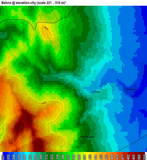
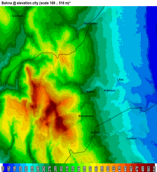
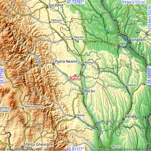
| \ | Map #1 | Map #2 | Topo.Map |
| Scale [m] | 221..516 m | 169..516 m | × |
| Scale [ft] | 725..1693 ft | 554..1693 ft | × |
| Average | 328.4 m = 1077 ft | 298.1 m = 978 ft | × |
| Width | 6.69 km = 4.2 mi | 13.38 km = 8.3 mi | 214.1 km = 133 mi |
| Height | 6.69 km = 4.2 mi | 13.38 km = 8.3 mi | 214.1 km = 133 mi |
| ↑Max Latitude | 46.813414° | 46.84348° | 47.73767° |
| Latitude at center | 46.78333° | 46.78333° | 46.78333° |
| ↓Min Latitude | 46.75323° | 46.723112° | 45.81177° |
| ← Min Longitude | 26.739385° | 26.695439° | 25.37708° |
| Longitude center | 26.78333° | 26.78333° | 26.78333° |
| →Max Longitude | 26.827275° | 26.871221° | 28.18958° |
Nearby cities:
Cities around Bahna sort by population:
• Buhuşi elevation 254 m
9.8 km,  220°
220°
• Filipeşti 173 m
8.5 km,  115°
115°
• Români 344 m
7.6 km,  270°
270°
• Racova 238 m
9.6 km,  195°
195°
• Bereşti-Bistriţa 254 m
8.3 km,  152°
152°
• Moldoveni 283 m
5.7 km,  347°
347°
• Siliștea 257 m
6.9 km,  264°
264°
• Izvoare 278 m
4.3 km,  160°
160°
• Goșmani 290 m
7.8 km,  318°
318°
• Hociungi 344 m
3.4 km, 350°
• Cârligi 208 m
5.5 km,  110°
110°
• Secuieni 223 m
8.3 km,  27°
27°
Multilingual:
 En español:
Bahna elevación 282 m.
 En France:
Bahna élévation 282 m.


Sources and notes:
- [note 1] Map square and city borders are not equal. Map elevation data is calculated only from area inside that square.
- [src 1] Elevation data from geonames database provided with same terms of usage.
- [src 2] The elevation map of Bahna is generated using elevation data from NASA's 3 arcsec (90m) resolution SRTM data.
- [src 3] Base (background) map © OpenStreetMap contributors tiles are generated by Geofabrik and OpenTopoMap.
Copyright & License:
This Bahna Elevation Map is licensed under CC BY-SA. You may reuse any part from this page, if you give a proper credit by linking to this URL:
 More info on terms of use page.