Pădurea Neagră elevation
Pădurea Neagră (Bihor, Oraș Aleşd), Romania elevation is 377 meters and Pădurea Neagră elevation in feet is 1237 ft above sea level [src 1]. Pădurea Neagră is a populated place (feature code) with elevation that is 125 meters (410 ft) bigger than average city elevation in Romania.
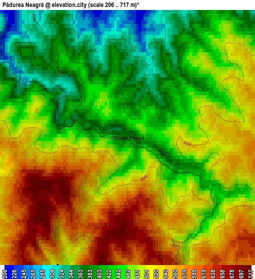
Below is the Elevation map of Pădurea Neagră, which displays elevation range with different colors. Scale of the first map is from 206 to 717 m (676 to 2352 ft) with average elevation of 479.6 meters (=1573 ft) [note 1]
These maps also provides idea of topography and contour of this city, they are displayed at different zoom levels. More info about maps, scale and edge coordinates you can find below images.
| \ | Map #1 | Topo.Map |
| Scale [m] | 206..717 m | × |
| Scale [ft] | 676..2352 ft | × |
| Average | 479.6 m = 1573 ft | × |
| Width | 6.64 km = 4.1 mi | 212.6 km = 132.1 mi |
| Height | 6.64 km = 4.1 mi | 212.6 km = 132.1 mi |
| ↑Max Latitude | 47.195409° | 48.11303° |
| Latitude at center | 47.16554° | 47.16554° |
| ↓Min Latitude | 47.135654° | 46.20084° |
| ← Min Longitude | 22.369285° | 21.00698° |
| Longitude center | 22.41323° | 22.41323° |
| →Max Longitude | 22.457175° | 23.81948° |
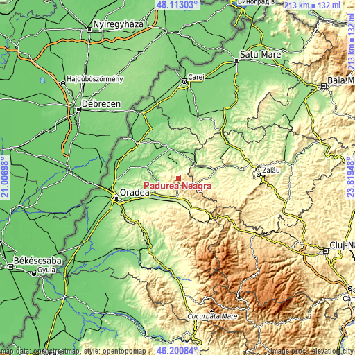
Nearby cities:
Cities around Pădurea Neagră sort by population:
• Aleşd elevation 255 m
11 km,  178°
178°
• Popeşti 169 m
7.5 km,  1°
1°
• Brusturi 157 m
12.5 km,  262°
262°
• Lugaşu de Jos 219 m
12 km,  203°
203°
• Derna 202 m
9.4 km,  294°
294°
• Voivozi 190 m
5.8 km,  342°
342°
• Peștiș 244 m
10.3 km, 180°
• Cuzap 196 m
4.2 km, 2°
• Bogei 147 m
11.8 km, 340°
• Şinteu 547 m
5.6 km,  108°
108°
• Bistra 176 m
9.9 km, 4°
• Ciutelec 163 m
10.9 km,  349°
349°
Multilingual:
 En español:
Pădurea Neagră elevación 377 m.
 En France:
Pădurea Neagră élévation 377 m.
 Auf Deutsch:
Pădurea Neagră höhe über dem Meeresspiegel ist 377 m.

Sources and notes:
- [note 1] Map square and city borders are not equal. Map elevation data is calculated only from area inside that square.
- [src 1] Elevation data from geonames database provided with same terms of usage.
- [src 2] The elevation map of Pădurea Neagră is generated using elevation data from NASA's 3 arcsec (90m) resolution SRTM data.
- [src 3] Base (background) map © OpenStreetMap contributors tiles are generated by Geofabrik and OpenTopoMap.
Copyright & License:
This Pădurea Neagră Elevation Map is licensed under CC BY-SA. You may reuse any part from this page, if you give a proper credit by linking to this URL:
 More info on terms of use page.