Ciutelec elevation
Ciutelec (Bihor, Comuna Tăuteu), Romania elevation is 163 meters and Ciutelec elevation in feet is 535 ft above sea level [src 1]. Ciutelec is a populated place (feature code) with elevation that is 89 meters (292 ft) smaller than average city elevation in Romania.
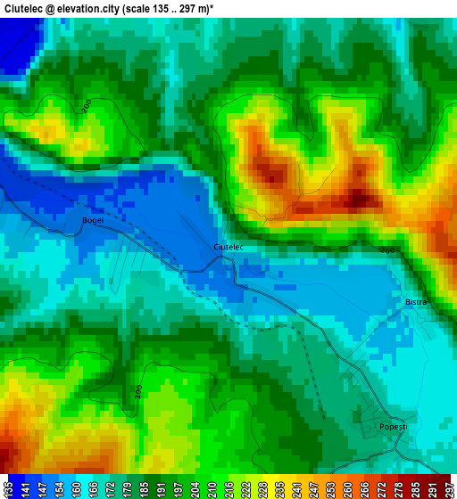
Below is the Elevation map of Ciutelec, which displays elevation range with different colors. Scale of the first map is from 135 to 297 m (443 to 974 ft) with average elevation of 189.8 meters (=623 ft) [note 1]
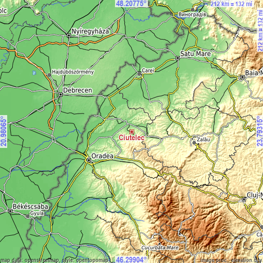
These maps also provides idea of topography and contour of this city, they are displayed at different zoom levels. More info about maps, scale and edge coordinates you can find below images.
| \ | Map #1 | Topo.Map |
| Scale [m] | 135..297 m | × |
| Scale [ft] | 443..974 ft | × |
| Average | 189.8 m = 623 ft | × |
| Width | 6.63 km = 4.1 mi | 212.2 km = 131.9 mi |
| Height | 6.63 km = 4.1 mi | 212.2 km = 131.9 mi |
| ↑Max Latitude | 47.291815° | 48.20775° |
| Latitude at center | 47.262° | 47.262° |
| ↓Min Latitude | 47.232168° | 46.29904° |
| ← Min Longitude | 22.342955° | 20.98065° |
| Longitude center | 22.3869° | 22.3869° |
| →Max Longitude | 22.430845° | 23.79315° |
Nearby cities:
Cities around Ciutelec sort by population:
• Marghita elevation 140 m
10.6 km,  337°
337°
• Popeşti 169 m
3.9 km,  144°
144°
• Tăuteu 154 m
4.1 km,  277°
277°
• Abram 130 m
6.1 km,  357°
357°
• Derna 202 m
9.5 km,  223°
223°
• Voivozi 190 m
5.2 km,  177°
177°
• Petreu 127 m
10.8 km,  320°
320°
• Cuzap 196 m
6.9 km,  161°
161°
• Bogei 147 m
2 km, 281°
• Bistra 176 m
2.8 km,  106°
106°
• Pădurea Neagră 377 m
10.9 km,  169°
169°
• Mișca 168 m
9.6 km,  270°
270°
Multilingual:
 En español:
Ciutelec elevación 163 m.
 En France:
Ciutelec élévation 163 m.
 Auf Deutsch:
Ciutelec höhe über dem Meeresspiegel ist 163 m.

Sources and notes:
- [note 1] Map square and city borders are not equal. Map elevation data is calculated only from area inside that square.
- [src 1] Elevation data from geonames database provided with same terms of usage.
- [src 2] The elevation map of Ciutelec is generated using elevation data from NASA's 3 arcsec (90m) resolution SRTM data.
- [src 3] Base (background) map © OpenStreetMap contributors tiles are generated by Geofabrik and OpenTopoMap.
Copyright & License:
This Ciutelec Elevation Map is licensed under CC BY-SA. You may reuse any part from this page, if you give a proper credit by linking to this URL:
 More info on terms of use page.