Derna elevation
Derna (Bihor, Comuna Derna), Romania elevation is 202 meters and Derna elevation in feet is 663 ft above sea level [src 1]. Derna is a seat of a second-order administrative division (feature code) with elevation that is 50 meters (164 ft) smaller than average city elevation in Romania.
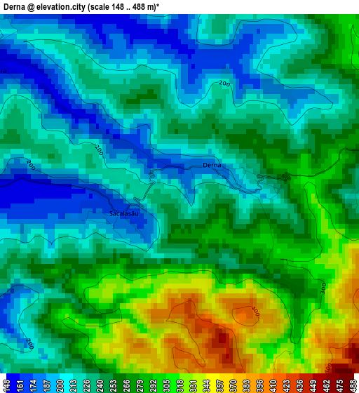
Below is the Elevation map of Derna, which displays elevation range with different colors. Scale of the first map is from 148 to 488 m (486 to 1601 ft) with average elevation of 249 meters (=817 ft) [note 1]
These maps also provides idea of topography and contour of this city, they are displayed at different zoom levels. More info about maps, scale and edge coordinates you can find below images.
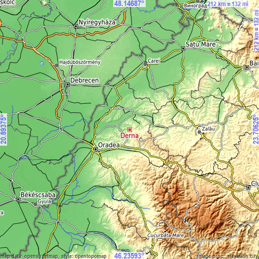
| \ | Map #1 | Topo.Map |
| Scale [m] | 148..488 m | × |
| Scale [ft] | 486..1601 ft | × |
| Average | 249 m = 817 ft | × |
| Width | 6.64 km = 4.1 mi | 212.5 km = 132 mi |
| Height | 6.64 km = 4.1 mi | 212.5 km = 132 mi |
| ↑Max Latitude | 47.22985° | 48.14687° |
| Latitude at center | 47.2° | 47.2° |
| ↓Min Latitude | 47.170133° | 46.23593° |
| ← Min Longitude | 22.256055° | 20.89375° |
| Longitude center | 22.3° | 22.3° |
| →Max Longitude | 22.343945° | 23.70625° |
Nearby cities:
Cities around Derna sort by population:
• Popeşti elevation 169 m
9.6 km,  67°
67°
• Tăuteu 154 m
7.8 km,  18°
18°
• Brusturi 157 m
6.7 km,  214°
214°
• Chişlaz 116 m
10.5 km,  331°
331°
• Voivozi 190 m
7 km,  75°
75°
• Cuzap 196 m
8.7 km,  87°
87°
• Bogei 147 m
8.6 km,  32°
32°
• Spinuş 129 m
7.6 km,  270°
270°
• Burzuc 161 m
10.9 km,  243°
243°
• Pădurea Neagră 377 m
9.4 km,  114°
114°
• Mișca 168 m
7.6 km,  336°
336°
• Ciutelec 163 m
9.5 km,  43°
43°
Multilingual:
 En español:
Derna elevación 202 m.
 En France:
Derna élévation 202 m.


Sources and notes:
- [note 1] Map square and city borders are not equal. Map elevation data is calculated only from area inside that square.
- [src 1] Elevation data from geonames database provided with same terms of usage.
- [src 2] The elevation map of Derna is generated using elevation data from NASA's 3 arcsec (90m) resolution SRTM data.
- [src 3] Base (background) map © OpenStreetMap contributors tiles are generated by Geofabrik and OpenTopoMap.
Copyright & License:
This Derna Elevation Map is licensed under CC BY-SA. You may reuse any part from this page, if you give a proper credit by linking to this URL:
 More info on terms of use page.