Aleşd elevation
Aleşd (Bihor, Oraș Aleşd), Romania elevation is 255 meters and Aleşd elevation in feet is 837 ft above sea level [src 1]. Aleşd is a seat of a second-order administrative division (feature code) with elevation that is 3 meters (10 ft) bigger than average city elevation in Romania.
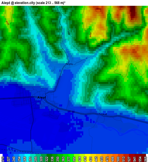
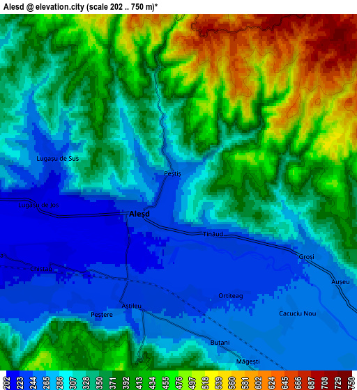
Below is the Elevation map of Aleşd, which displays elevation range with different colors. Scale of the first map is from 213 to 568 m (699 to 1864 ft) with average elevation of 296.7 meters (=973 ft) [note 1]
These maps also provides idea of topography and contour of this city, they are displayed at different zoom levels. More info about maps, scale and edge coordinates you can find below images.
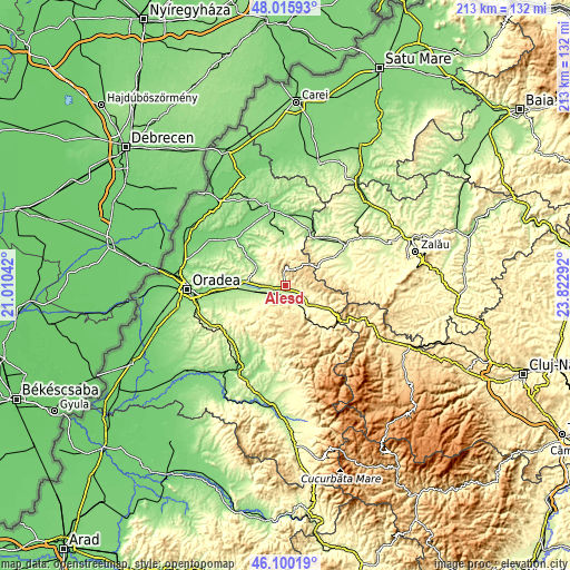
| \ | Map #1 | Map #2 | Topo.Map |
| Scale [m] | 213..568 m | 202..750 m | × |
| Scale [ft] | 699..1864 ft | 663..2461 ft | × |
| Average | 296.7 m = 973 ft | 351.1 m = 1152 ft | × |
| Width | 6.66 km = 4.1 mi | 13.31 km = 8.3 mi | 213 km = 132.4 mi |
| Height | 6.66 km = 4.1 mi | 13.31 km = 8.3 mi | 213 km = 132.4 mi |
| ↑Max Latitude | 47.096595° | 47.126503° | 48.01593° |
| Latitude at center | 47.06667° | 47.06667° | 47.06667° |
| ↓Min Latitude | 47.036728° | 47.00677° | 46.10019° |
| ← Min Longitude | 22.372725° | 22.328779° | 21.01042° |
| Longitude center | 22.41667° | 22.41667° | 22.41667° |
| →Max Longitude | 22.460615° | 22.504561° | 23.82292° |
Nearby cities:
Cities around Aleşd sort by population:
• Vadu Crişului elevation 277 m
12 km,  140°
140°
• Aştileu 229 m
4.5 km,  214°
214°
• Lugaşu de Jos 219 m
5 km,  270°
270°
• Auşeu 252 m
7.3 km,  120°
120°
• Măgeşti 252 m
6.1 km,  155°
155°
• Vârciorog 379 m
14.2 km,  218°
218°
• Peștiș 244 m
0.7 km,  332°
332°
• Şinteu 547 m
10.5 km,  28°
28°
• Luncșoara 303 m
10.1 km,  109°
109°
• Hotar 226 m
11.3 km,  242°
242°
• Pădurea Neagră 377 m
11 km,  358°
358°
• Groși 248 m
5.3 km, 116°
Multilingual:
 En español:
Aleşd elevación 255 m.
 En France:
Aleşd élévation 255 m.


Sources and notes:
- [note 1] Map square and city borders are not equal. Map elevation data is calculated only from area inside that square.
- [src 1] Elevation data from geonames database provided with same terms of usage.
- [src 2] The elevation map of Aleşd is generated using elevation data from NASA's 3 arcsec (90m) resolution SRTM data.
- [src 3] Base (background) map © OpenStreetMap contributors tiles are generated by Geofabrik and OpenTopoMap.
Copyright & License:
This Aleşd Elevation Map is licensed under CC BY-SA. You may reuse any part from this page, if you give a proper credit by linking to this URL:
 More info on terms of use page.