Vârciorog elevation
Vârciorog (Bihor, Comuna Vârciorog), Romania elevation is 379 meters and Vârciorog elevation in feet is 1243 ft above sea level [src 1]. Vârciorog is a seat of a second-order administrative division (feature code) with elevation that is 127 meters (417 ft) bigger than average city elevation in Romania.
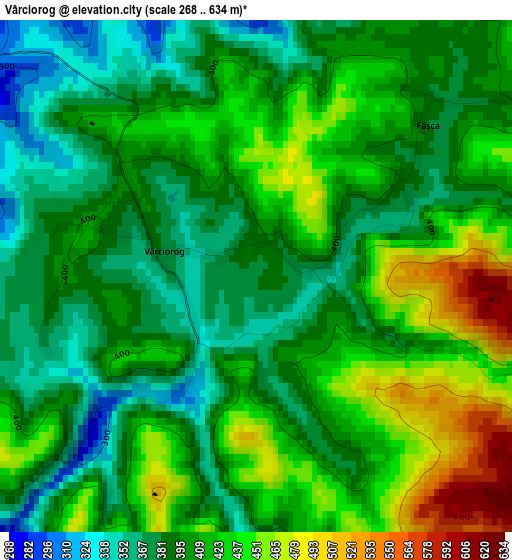
Below is the Elevation map of Vârciorog, which displays elevation range with different colors. Scale of the first map is from 268 to 634 m (879 to 2080 ft) with average elevation of 407.6 meters (=1337 ft) [note 1]
These maps also provides idea of topography and contour of this city, they are displayed at different zoom levels. More info about maps, scale and edge coordinates you can find below images.
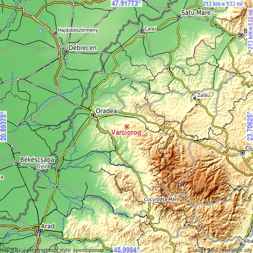
| \ | Map #1 | Topo.Map |
| Scale [m] | 268..634 m | × |
| Scale [ft] | 879..2080 ft | × |
| Average | 407.6 m = 1337 ft | × |
| Width | 6.67 km = 4.1 mi | 213.4 km = 132.6 mi |
| Height | 6.67 km = 4.1 mi | 213.4 km = 132.6 mi |
| ↑Max Latitude | 46.996651° | 47.91773° |
| Latitude at center | 46.96667° | 46.96667° |
| ↓Min Latitude | 46.936672° | 45.9984° |
| ← Min Longitude | 22.256055° | 20.89375° |
| Longitude center | 22.3° | 22.3° |
| →Max Longitude | 22.343945° | 23.70625° |
Nearby cities:
Cities around Vârciorog sort by population:
• Aleşd elevation 255 m
14.2 km,  38°
38°
• Tileagd 172 m
13.5 km,  325°
325°
• Dobreşti 273 m
13 km,  180°
180°
• Ceica 153 m
15.7 km,  214°
214°
• Aştileu 229 m
9.7 km, 40°
• Lugaşu de Jos 219 m
11.7 km,  18°
18°
• Măgeşti 252 m
12.7 km,  63°
63°
• Copăcel 209 m
10.3 km,  280°
280°
• Săcădat 184 m
13.6 km,  303°
303°
• Peștiș 244 m
14.5 km, 35°
• Tășad 308 m
13.7 km,  256°
256°
• Hotar 226 m
6 km,  349°
349°
Multilingual:
 En español:
Vârciorog elevación 379 m.
 En France:
Vârciorog élévation 379 m.
 Auf Deutsch:
Vârciorog höhe über dem Meeresspiegel ist 379 m.

Sources and notes:
- [note 1] Map square and city borders are not equal. Map elevation data is calculated only from area inside that square.
- [src 1] Elevation data from geonames database provided with same terms of usage.
- [src 2] The elevation map of Vârciorog is generated using elevation data from NASA's 3 arcsec (90m) resolution SRTM data.
- [src 3] Base (background) map © OpenStreetMap contributors tiles are generated by Geofabrik and OpenTopoMap.
Copyright & License:
This Vârciorog Elevation Map is licensed under CC BY-SA. You may reuse any part from this page, if you give a proper credit by linking to this URL:
 More info on terms of use page.