Tășad elevation
Tășad (Bihor, Comuna Drăgeşti), Romania elevation is 308 meters and Tășad elevation in feet is 1010 ft above sea level [src 1]. Tășad is a populated place (feature code) with elevation that is 56 meters (184 ft) bigger than average city elevation in Romania.
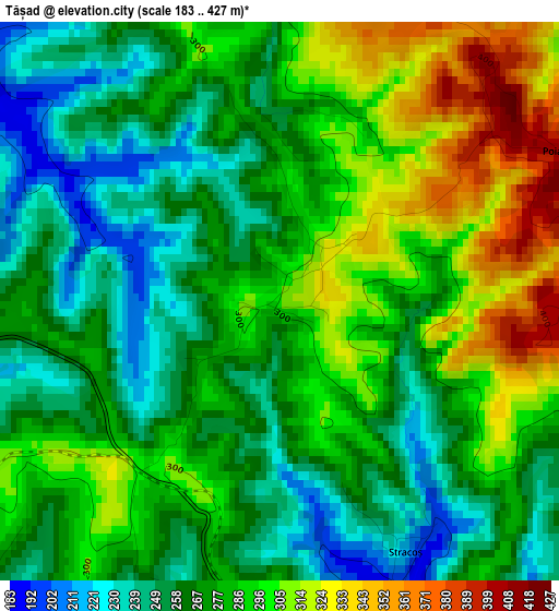
Below is the Elevation map of Tășad, which displays elevation range with different colors. Scale of the first map is from 183 to 427 m (600 to 1401 ft) with average elevation of 278.9 meters (=915 ft) [note 1]
These maps also provides idea of topography and contour of this city, they are displayed at different zoom levels. More info about maps, scale and edge coordinates you can find below images.
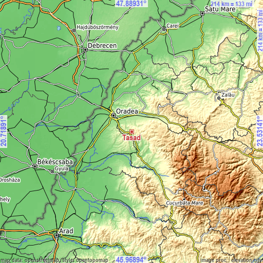
| \ | Map #1 | Topo.Map |
| Scale [m] | 183..427 m | × |
| Scale [ft] | 600..1401 ft | × |
| Average | 278.9 m = 915 ft | × |
| Width | 6.67 km = 4.1 mi | 213.5 km = 132.7 mi |
| Height | 6.67 km = 4.1 mi | 213.5 km = 132.7 mi |
| ↑Max Latitude | 46.967727° | 47.88931° |
| Latitude at center | 46.93773° | 46.93773° |
| ↓Min Latitude | 46.907716° | 45.96894° |
| ← Min Longitude | 22.081215° | 20.71891° |
| Longitude center | 22.12516° | 22.12516° |
| →Max Longitude | 22.169105° | 23.53141° |
Nearby cities:
Cities around Tășad sort by population:
• Ceica elevation 153 m
10.7 km,  155°
155°
• Sînmartin 148 m
13.8 km,  304°
304°
• Hidişelu de Sus 243 m
5.9 km,  283°
283°
• Oșorhei 157 m
12.1 km,  331°
331°
• Lăzăreni 294 m
9.1 km,  209°
209°
• Drăgeşti 217 m
6.1 km,  174°
174°
• Copăcel 209 m
6 km,  31°
31°
• Vârciorog 379 m
13.7 km,  76°
76°
• Săcădat 184 m
10.8 km,  10°
10°
• Cordău 261 m
10.9 km, 277°
• Hotar 226 m
15.2 km,  53°
53°
• Alparea 162 m
11.9 km, 330°
Multilingual:
 En español:
Tășad elevación 308 m.
 En France:
Tășad élévation 308 m.


Sources and notes:
- [note 1] Map square and city borders are not equal. Map elevation data is calculated only from area inside that square.
- [src 1] Elevation data from geonames database provided with same terms of usage.
- [src 2] The elevation map of Tășad is generated using elevation data from NASA's 3 arcsec (90m) resolution SRTM data.
- [src 3] Base (background) map © OpenStreetMap contributors tiles are generated by Geofabrik and OpenTopoMap.
Copyright & License:
This Tășad Elevation Map is licensed under CC BY-SA. You may reuse any part from this page, if you give a proper credit by linking to this URL:
 More info on terms of use page.