Oșorhei elevation
Oșorhei (Bihor, Comuna Oşorhei), Romania elevation is 157 meters and Oșorhei elevation in feet is 515 ft above sea level [src 1]. Oșorhei is a seat of a second-order administrative division (feature code) with elevation that is 95 meters (312 ft) smaller than average city elevation in Romania.
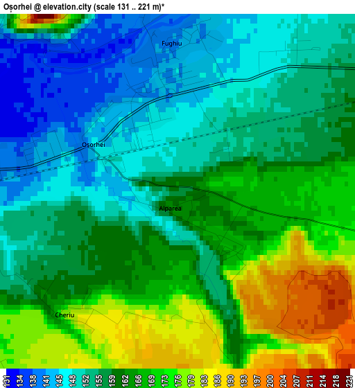
Below is the Elevation map of Oșorhei, which displays elevation range with different colors. Scale of the first map is from 131 to 221 m (430 to 725 ft) with average elevation of 160.2 meters (=526 ft) [note 1]
These maps also provides idea of topography and contour of this city, they are displayed at different zoom levels. More info about maps, scale and edge coordinates you can find below images.
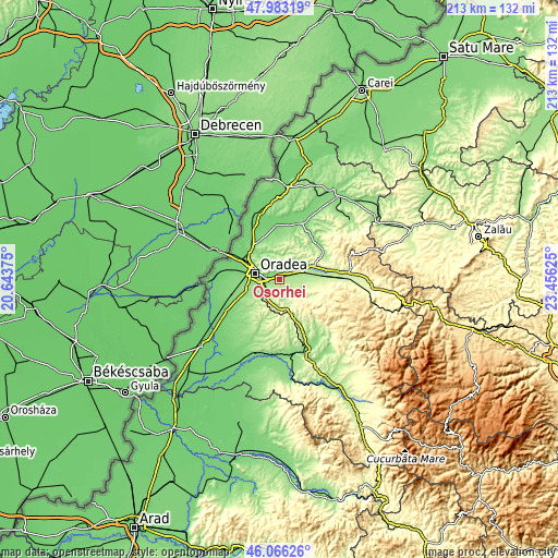
| \ | Map #1 | Topo.Map |
| Scale [m] | 131..221 m | × |
| Scale [ft] | 430..725 ft | × |
| Average | 160.2 m = 526 ft | × |
| Width | 6.66 km = 4.1 mi | 213.1 km = 132.4 mi |
| Height | 6.66 km = 4.1 mi | 213.1 km = 132.4 mi |
| ↑Max Latitude | 47.063274° | 47.98319° |
| Latitude at center | 47.03333° | 47.03333° |
| ↓Min Latitude | 47.00337° | 46.06626° |
| ← Min Longitude | 22.006055° | 20.64375° |
| Longitude center | 22.05° | 22.05° |
| →Max Longitude | 22.093945° | 23.45625° |
Nearby cities:
Cities around Oșorhei sort by population:
• Oradea elevation 123 m
10.1 km,  277°
277°
• Tileagd 172 m
12 km,  71°
71°
• Ineu 156 m
7.5 km,  42°
42°
• Sînmartin 148 m
6.4 km,  243°
243°
• Cetariu 194 m
11.4 km,  347°
347°
• Hidişelu de Sus 243 m
9.3 km,  180°
180°
• Copăcel 209 m
10.4 km,  122°
122°
• Săcădat 184 m
7.6 km,  90°
90°
• Cordău 261 m
10.6 km,  208°
208°
• Tășad 308 m
12.1 km,  151°
151°
• Alparea 162 m
0.3 km,  204°
204°
• Paleu 166 m
11.4 km,  322°
322°
Multilingual:
 En español:
Oșorhei elevación 157 m.
 En France:
Oșorhei élévation 157 m.


Sources and notes:
- [note 1] Map square and city borders are not equal. Map elevation data is calculated only from area inside that square.
- [src 1] Elevation data from geonames database provided with same terms of usage.
- [src 2] The elevation map of Oșorhei is generated using elevation data from NASA's 3 arcsec (90m) resolution SRTM data.
- [src 3] Base (background) map © OpenStreetMap contributors tiles are generated by Geofabrik and OpenTopoMap.
Copyright & License:
This Oșorhei Elevation Map is licensed under CC BY-SA. You may reuse any part from this page, if you give a proper credit by linking to this URL:
 More info on terms of use page.