Sînmartin elevation
Sînmartin (Bihor, Comuna Sânmartin), Romania elevation is 148 meters and Sînmartin elevation in feet is 486 ft above sea level [src 1]. Sînmartin is a populated place (feature code) with elevation that is 104 meters (341 ft) smaller than average city elevation in Romania.
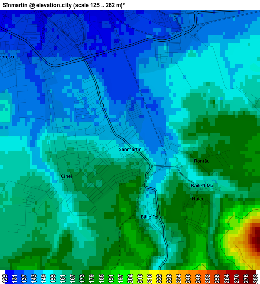
Below is the Elevation map of Sînmartin, which displays elevation range with different colors. Scale of the first map is from 125 to 282 m (410 to 925 ft) with average elevation of 157.8 meters (=518 ft) [note 1]
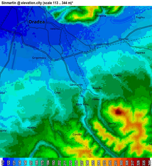
These maps also provides idea of topography and contour of this city, they are displayed at different zoom levels. More info about maps, scale and edge coordinates you can find below images.
| \ | Map #1 | Map #2 | Topo.Map |
| Scale [m] | 125..282 m | 113..344 m | × |
| Scale [ft] | 410..925 ft | 371..1129 ft | × |
| Average | 157.8 m = 518 ft | 169.3 m = 555 ft | × |
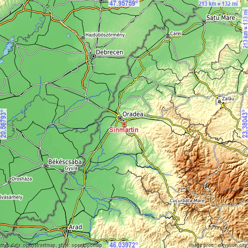
| Width | 6.66 km = 4.1 mi | 13.33 km = 8.3 mi | 213.2 km = 132.5 mi |
| Height | 6.66 km = 4.1 mi | 13.33 km = 8.3 mi | 213.2 km = 132.5 mi |
| ↑Max Latitude | 47.037218° | 47.067159° | 47.95759° |
| Latitude at center | 47.00726° | 47.00726° | 47.00726° |
| ↓Min Latitude | 46.977285° | 46.947293° | 46.03972° |
| ← Min Longitude | 21.930235° | 21.886289° | 20.56793° |
| Longitude center | 21.97418° | 21.97418° | 21.97418° |
| →Max Longitude | 22.018125° | 22.062071° | 23.38043° |
Nearby cities:
Cities around Sînmartin sort by population:
• Oradea elevation 123 m
6 km,  315°
315°
• Nojorid 145 m
7.4 km,  248°
248°
• Ineu 156 m
13.7 km,  51°
51°
• Sântandrei 112 m
11.2 km,  305°
305°
• Hidişelu de Sus 243 m
8.6 km,  137°
137°
• Oșorhei 157 m
6.4 km,  63°
63°
• Săcădat 184 m
13.6 km,  77°
77°
• Cordău 261 m
6.4 km,  173°
173°
• Tășad 308 m
13.8 km,  124°
124°
• Livada de Bihor 125 m
12.6 km,  271°
271°
• Alparea 162 m
6.2 km,  65°
65°
• Paleu 166 m
12.1 km,  354°
354°
Multilingual:
 En español:
Sînmartin elevación 148 m.
 En France:
Sînmartin élévation 148 m.
 Auf Deutsch:
Sînmartin höhe über dem Meeresspiegel ist 148 m.

Sources and notes:
- [note 1] Map square and city borders are not equal. Map elevation data is calculated only from area inside that square.
- [src 1] Elevation data from geonames database provided with same terms of usage.
- [src 2] The elevation map of Sînmartin is generated using elevation data from NASA's 3 arcsec (90m) resolution SRTM data.
- [src 3] Base (background) map © OpenStreetMap contributors tiles are generated by Geofabrik and OpenTopoMap.
Copyright & License:
This Sînmartin Elevation Map is licensed under CC BY-SA. You may reuse any part from this page, if you give a proper credit by linking to this URL:
 More info on terms of use page.